
Argentina topographic map
Interactive map
Click on the map to display elevation.
About this map
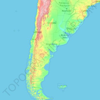
Name: Argentina topographic map, elevation, terrain.
Location: Argentina (-55.19257 -73.56054 -21.78086 -53.63745)
Average elevation: 198 m
Minimum elevation: -2 m
Maximum elevation: 6,482 m
In general, Argentina has four main climate types: warm, moderate, arid, and cold, all determined by the expanse across latitude, range in altitude, and relief features. Although the most populated areas are generally temperate, Argentina has an exceptional amount of climate diversity, ranging from subtropical in the north to polar in the far south. Consequently, there is a wide variety of biomes in the country, including subtropical rain forests, semi-arid and arid regions, temperate plains in the Pampas, and cold subantarctic in the south. The average annual precipitation ranges from 150 millimetres (6 in) in the driest parts of Patagonia to over 2,000 millimetres (79 in) in the westernmost parts of Patagonia and the northeastern parts of the country. Mean annual temperatures range from 5 °C (41 °F) in the far south to 25 °C (77 °F) in the north.
Other topographic maps
Click on a map to view its topography, its elevation and its terrain.
Ireland
Ireland
Average elevation: 44 m
Chasiv Yar
Chasiv Yar, Chasiv Yar urban hromada, Bakhmut Raion, Donetsk Oblast, 84551-84556, Ukraine
Average elevation: 213 m
Monterey County
Monterey County, California, United States
Average elevation: 282 m
Europe
Europe
Average elevation: 223 m
Cork
Ireland > County Cork > Cork
Cork, County Cork, Munster, T12 T997, Ireland
Average elevation: 94 m
Bangladesh
Bangladesh
Average elevation: 161 m
Czechia
Czechia
Average elevation: 369 m
Croatia
Croatia
Average elevation: 323 m
Portlaoise
Portlaoise, The Municipal District of Portlaoise, County Laois, Leinster, Ireland
Average elevation: 101 m
Lisacul
Lisacul, Roscommon Municipal District, County Roscommon, Connacht, Ireland
Average elevation: 82 m
Leckaun
Leckaun, Drumkeeran ED, Manorhamilton Municipal District, County Leitrim, Connacht, Ireland
Average elevation: 220 m
Pretoria
South Africa > Gauteng > City of Tshwane Metropolitan Municipality
Pretoria, City of Tshwane Metropolitan Municipality, Gauteng, 0126, South Africa
Average elevation: 1,363 m
Cornwall
United Kingdom > England > Fairy Cross
Cornwall, Broadoak, Fairy Cross, Cornwall, South West England, England, United Kingdom
Average elevation: 49 m
Tooele County
United States of America > Utah
Tooele County, Utah, United States of America
Average elevation: 1,462 m
High Wycombe
United Kingdom > England > Buckinghamshire
High Wycombe, Buckinghamshire, England, United Kingdom
Average elevation: 124 m
San Bernardino County
San Bernardino County, California, United States
Average elevation: 763 m
Leedstown
United Kingdom > England > Cornwall
Leedstown, Cornwall, England, TR27 6DB, United Kingdom
Average elevation: 73 m
Ballaghaderreen
Ballaghaderreen, Ballaghaderreen ED, Boyle Municipal District, County Roscommon, Connacht, F45 XT73, Ireland
Average elevation: 84 m
Knock
Knock, Claremorris-Swinford Municipal District, County Mayo, Connacht, F12 KF89, Ireland
Average elevation: 94 m
Rathcormack
Rathcormack, Drumcliff South, Drumcliff West ED, Sligo Municipal Borough District, County Sligo, Connacht, F91 PY24, Ireland
Average elevation: 27 m
Taiwan
Taiwan > Taiwan Province > Xinyi Township
Taiwan, Xinyi Township, Nantou County, Taiwan Province, Taiwan
Average elevation: 196 m
Madagascar
Madagascar
Average elevation: 139 m
Makhuduthamaga Local Municipality
South Africa > Limpopo > Sekhukhune District Municipality
Makhuduthamaga Local Municipality, Sekhukhune District Municipality, Limpopo, South Africa
Average elevation: 1,140 m
Crowborough
United Kingdom > England > East Sussex > Wealden
Crowborough, Wealden, East Sussex, England, United Kingdom
Average elevation: 146 m
Cabernardi
Italy > Marche > Ancona > Sassoferrato
Cabernardi, Sassoferrato, Ancona, Marche, Italy
Average elevation: 381 m
Utrillas
Spain > Aragon > Cuencas Mineras
Utrillas, Cuencas Mineras, Teruel, Aragon, 44760, Spain
Average elevation: 1,159 m
La Zoma
Spain > Aragon > Cuencas Mineras
La Zoma, Cuencas Mineras, Teruel, Aragon, Spain
Average elevation: 1,256 m
Villarluengo
Spain > Aragon > Maestrazgo
Villarluengo, Maestrazgo, Teruel, Aragon, Spain
Average elevation: 1,265 m
Forcall
Forcall, els Ports, Castelló / Castellón, Valencian Community, 12310, Spain
Average elevation: 854 m
Morella
Morella, els Ports, Castelló / Castellón, Valencian Community, Spain
Average elevation: 949 m
Itchen Abbas
United Kingdom > England > Hampshire > Winchester
Itchen Abbas, Winchester, Hampshire, England, SO21 1DJ, United Kingdom
Average elevation: 81 m
Ballinacor East
Ballinacor East, Dunganstown South ED, The Municipal District of Arklow, County Wicklow, Leinster, Ireland
Average elevation: 65 m
El Dorado County
El Dorado County, California, United States
Average elevation: 1,286 m
San Sebastián
Spain > Autonomous Community of the Basque Country
San Sebastián, Gipuzkoa, Autonomous Community of the Basque Country, Spain
Average elevation: 120 m
Mada'in
Mada'in, Tell Al-Daman Subdistrict, Mount Simeon District, Aleppo Governorate, Syria
Average elevation: 402 m
Baghdad
Baghdad, Green Zone Municipality, Baghdad Governorate, Iraq
Average elevation: 36 m