
Saudi Arabia topographic map
Interactive map
Click on the map to display elevation.
About this map
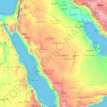
Name: Saudi Arabia topographic map, elevation, terrain.
Location: Saudi Arabia (16.29000 34.45717 32.15434 55.66669)
Average elevation: 551 m
Minimum elevation: -415 m
Maximum elevation: 3,894 m
Saudi Arabia's diverse geography is dominated by the Arabian Desert, associated semi-desert, shrubland, steppes, several mountain ranges, volcanic lava fields and highlands. The 647,500 km2 (250,001 sq mi) Rub' al Khali ("Empty Quarter") in the southeastern part of the country is the world's largest contiguous sand desert. Though there are lakes in the country, Saudi Arabia is the largest country in the world by area with no permanent rivers. Wadis, non-permanent rivers, however, are very numerous. The fertile areas are to be found in the alluvial deposits in wadis, basins, and oases. The main topographical feature is the central plateau which rises abruptly from the Red Sea and gradually descends into the Nejd and toward the Persian Gulf. On the Red Sea coast, there is a narrow coastal plain, known as the Tihamah parallel to which runs an imposing escarpment. The southwest province of Asir is mountainous, and contains the 3,133 m (10,279 ft) Mount Sawda, which is the highest point in the country. Saudi Arabia is home to more than 2000 dormant volcanoes. Lava fields in Hejaz, known locally by their Arabic name of harrat (the singular is harrah), form one of Earth's largest alkali basalt regions, covering some 180,000 square kilometres (69,000 sq mi), an area greater than the state of Missouri.
Other topographic maps
Click on a map to view its topography, its elevation and its terrain.
Ireland
Ireland
Average elevation: 44 m
Chasiv Yar
Chasiv Yar, Chasiv Yar urban hromada, Bakhmut Raion, Donetsk Oblast, 84551-84556, Ukraine
Average elevation: 213 m
Bangladesh
Bangladesh
Average elevation: 161 m
Croatia
Croatia
Average elevation: 323 m
Kilmihil
Kilmihil, West Clare Municipal District, County Clare, Munster, Ireland
Average elevation: 69 m
Carrigaholt
Carrigaholt, West Clare Municipal District, County Clare, Munster, Ireland
Average elevation: 15 m
Vladikavkaz
Russia > Republic of North Ossetia – Alania > Vladikavkaz City District
Vladikavkaz, Vladikavkaz City District, Republic of North Ossetia – Alania, North Caucasian Federal District, Russia
Average elevation: 734 m
Karabakh
Karabakh, Khojaly District, Karabakh, Azerbaijan
Average elevation: 1,055 m
Monterey County
Monterey County, California, United States
Average elevation: 282 m
El Dorado County
El Dorado County, California, United States
Average elevation: 1,286 m
Victorville
United States > California > San Bernardino County
Victorville, San Bernardino County, California, United States
Average elevation: 920 m
Europe
Europe
Average elevation: 223 m
Kilgobbin
Kilgobbin, Ballinadee ED, The Municipal District of Bandon-Kinsale, County Cork, Munster, Ireland
Average elevation: 85 m
Kilgobbin
Ireland > County Dublin > Stepaside
Kilgobbin, Glencullen Electoral Division, Stepaside, Dún Laoghaire-Rathdown, County Dublin, Leinster, Ireland
Average elevation: 143 m
Cerro Chachagua
Cerro Chachagua, Wiwilí (Municipio), Nueva Segovia, 39100, Nicaragua
Average elevation: 901 m
Galway City
Galway, Galway City, County Galway, Connacht, H91 YD86, Ireland
Average elevation: 26 m
Valencia
Spain > Valencian Community > Comarca de València
Valencia, Comarca de València, Valencia, Valencian Community, Spain
Average elevation: 37 m
Taiwan
Taiwan > Taiwan Province > Xinyi Township
Taiwan, Xinyi Township, Nantou County, Taiwan Province, Taiwan
Average elevation: 196 m
Madagascar
Madagascar
Average elevation: 139 m
Czechia
Czechia
Average elevation: 369 m
Cork
Ireland > County Cork > Cork
Cork, County Cork, Munster, T12 T997, Ireland
Average elevation: 94 m
Newquay
Newquay, Abbey ED, West Clare Municipal District, County Clare, Munster, Ireland
Average elevation: 7 m
Flaggy
Flaggy, Cooktown, Cook Shire, Queensland, Australia
Average elevation: 39 m
Kilrush
Kilrush, West Clare Municipal District, County Clare, Munster, Ireland
Average elevation: 22 m
Dallas
United States > Texas > Dallas County
Dallas, Dallas County, Texas, United States
Average elevation: 160 m
Culleenatreen
Culleenatreen, Danesfort ED, Boyle Municipal District, County Roscommon, Connacht, Ireland
Average elevation: 65 m
Navvy Jack Point Park
Canada > British Columbia > Metro Vancouver Regional District > West Vancouver
Navvy Jack Point Park, Ambleside, West Vancouver, Metro Vancouver Regional District, British Columbia, Canada
Average elevation: 23 m
Kazan
Russia > Tatarstan > городской округ Казань
Kazan, городской округ Казань, Tatarstan, Volga Federal District, Russia
Average elevation: 104 m
Tooele County
United States of America > Utah
Tooele County, Utah, United States of America
Average elevation: 1,462 m
San Bernardino County
San Bernardino County, California, United States
Average elevation: 763 m
Rathcormack
Rathcormack, Drumcliff South, Drumcliff West ED, Sligo Municipal Borough District, County Sligo, Connacht, F91 PY24, Ireland
Average elevation: 27 m
Toliara
Toliara, Atsimo-Andrefana, Province de Toliara, 601, Madagascar
Average elevation: 38 m
Glenfarne
Glenfarne, Glenfarn ED, Manorhamilton Municipal District, County Leitrim, Connacht, Ireland
Average elevation: 90 m
Miłomłyn
Poland > Warmian-Masurian Voivodeship > Ostróda County
Miłomłyn, gmina Miłomłyn, Ostróda County, Warmian-Masurian Voivodeship, 14-140, Poland
Average elevation: 109 m
El Salvador
El Salvador
Average elevation: 484 m