
Thank you for supporting this site ❤️
Make a donation
Make a donation
Gear up for your next adventure:
As an Amazon Associate, this site earns from qualifying purchases at no extra cost to you.
Karabakh topographic map
Click on the map to display elevation.
Thank you for supporting this site ❤️
Make a donation
Make a donation
Gear up for your next adventure:
As an Amazon Associate, this site earns from qualifying purchases at no extra cost to you.
About this map
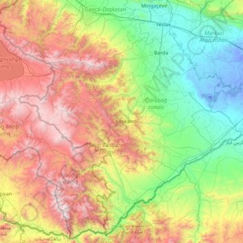
Name: Karabakh topographic map, elevation, terrain.
Location: Karabakh, Khojaly District, Karabakh, Azerbaijan (38.80792 45.69772 40.80792 47.69772)
Average elevation: 1,055 m
Minimum elevation: -11 m
Maximum elevation: 3,754 m
Thank you for supporting this site ❤️
Make a donation
Make a donation
Gear up for your next adventure:
As an Amazon Associate, this site earns from qualifying purchases at no extra cost to you.