
Bulgaria topographic map
Interactive map
Click on the map to display elevation.
About this map
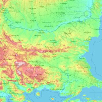
Name: Bulgaria topographic map, elevation, terrain.
Location: Bulgaria (41.23537 22.35715 44.21554 28.88754)
Average elevation: 300 m
Minimum elevation: -3 m
Maximum elevation: 2,750 m
Bulgaria is a small country situated in Southeastern Europe, in the east of the Balkans. Its territory covers an area of 110,994 square kilometres (42,855 sq mi), while land borders with its five neighbouring countries run a total length of 1,808 kilometres (1,123 mi), and its coastline is 354 kilometres (220 mi) long. Bulgaria's geographic coordinates are 43° N 25° E. The most notable topographical features of the country are the Danubian Plain, the Balkan Mountains, the Thracian Plain, and the Rila-Rhodope massif. The southern edge of the Danubian Plain slopes upward into the foothills of the Balkans, while the Danube defines the border with Romania. The Thracian Plain is roughly triangular, beginning southeast of Sofia and broadening as it reaches the Black Sea coast.
Other topographic maps
Click on a map to view its topography, its elevation and its terrain.
Ireland
Ireland
Average elevation: 44 m
Chasiv Yar
Chasiv Yar, Chasiv Yar urban hromada, Bakhmut Raion, Donetsk Oblast, 84551-84556, Ukraine
Average elevation: 213 m
Czechia
Czechia
Average elevation: 369 m
Croatia
Croatia
Average elevation: 323 m
Cork
Ireland > County Cork > Cork
Cork, County Cork, Munster, T12 T997, Ireland
Average elevation: 94 m
Itchen Abbas
United Kingdom > England > Hampshire > Winchester
Itchen Abbas, Winchester, Hampshire, England, SO21 1DJ, United Kingdom
Average elevation: 81 m
Latvia
Latvia
Average elevation: 72 m
Valencia
Spain > Valencian Community > Comarca de València
Valencia, Comarca de València, Valencia, Valencian Community, Spain
Average elevation: 37 m
Taiwan
Taiwan > Taiwan Province > Xinyi Township
Taiwan, Xinyi Township, Nantou County, Taiwan Province, Taiwan
Average elevation: 196 m
Bangladesh
Bangladesh
Average elevation: 161 m
Nacogdoches County
Nacogdoches County, Texas, United States
Average elevation: 93 m
Toliara
Toliara, Atsimo-Andrefana, Province de Toliara, 601, Madagascar
Average elevation: 38 m
Madagascar
Madagascar
Average elevation: 139 m
Zoodochos Pigi
Greece > Thessaly and Central Greece > Euboea Regional Unit
Zoodochos Pigi, Mantoudi - Limni - Aghia Anna Municipality, Euboea Regional Unit, Central Greece, Thessaly and Central Greece, 340 04, Greece
Average elevation: 80 m
Nayaro
Indonesia > Central Papua > Mimika
Nayaro, Mimika, Central Papua, Western New Guinea, Indonesia
Average elevation: 100 m
St Mullins
St Mullins, The Municipal District of Muinebeag, The Municipal District of New Ross, County Carlow, Leinster, Ireland
Average elevation: 138 m
Ballinacor East
Ballinacor East, Dunganstown South ED, The Municipal District of Arklow, County Wicklow, Leinster, Ireland
Average elevation: 65 m
Ardfinnan
Ardfinnan, The Municipal District of Cahir — Cashel, County Tipperary, Munster, E91 A7D8, Ireland
Average elevation: 51 m
Cornwall
United Kingdom > England > Fairy Cross
Cornwall, Broadoak, Fairy Cross, Cornwall, South West England, England, United Kingdom
Average elevation: 49 m
Monterey County
Monterey County, California, United States
Average elevation: 282 m
El Dorado County
El Dorado County, California, United States
Average elevation: 1,286 m
Europe
Europe
Average elevation: 223 m
Lausanne
Switzerland > Vaud > District de Lausanne
Lausanne, District de Lausanne, Vaud, Switzerland
Average elevation: 621 m
Harbor Springs
United States > Michigan > Emmet County
Harbor Springs, Emmet County, Michigan, United States
Average elevation: 208 m
Wyong
Wyong, Central Coast Council, New South Wales, 2259, Australia
Average elevation: 9 m
Rathcormack
Rathcormack, Drumcliff South, Drumcliff West ED, Sligo Municipal Borough District, County Sligo, Connacht, F91 PY24, Ireland
Average elevation: 27 m
Kageshwori Manohara
Nepal > Bagmati Province > Kathmandu
Kageshwori Manohara, Kageshwori Manohara Municipality, Kathmandu, Bagmati Province, 46603, Nepal
Average elevation: 1,386 m
Tilolwa
Kenya > Nandi County > Chesumei > Chemundu ward
Tilolwa, Baraton sublocation, Chemundu ward, Chesumei, Nandi County, Rift Valley, 30306, Kenya
Average elevation: 1,966 m
Barkers Vale
Barkers Vale, Kyogle Council, New South Wales, 2474, Australia
Average elevation: 262 m
Ballitore
Ballitore, The Municipal District of Athy, County Kildare, Leinster, Ireland
Average elevation: 114 m
Sominot
Philippines > Zamboanga del Sur
Sominot, Zamboanga del Sur, Zamboanga Peninsula, 7022, Philippines
Average elevation: 261 m
O’Briensbridge
O’Briensbridge, Killaloe Municipal District, County Clare, Munster, Ireland
Average elevation: 41 m
High Wycombe
United Kingdom > England > Buckinghamshire
High Wycombe, Buckinghamshire, England, United Kingdom
Average elevation: 124 m
San Bernardino County
San Bernardino County, California, United States
Average elevation: 763 m
Milford
United States > Connecticut > South Central Connecticut Planning Region
Milford, South Central Connecticut Planning Region, Connecticut, United States
Average elevation: 18 m
Rochester
United States > Iowa > Cedar County
Rochester, Cedar County, Iowa, United States
Average elevation: 216 m