
Estonia topographic map
Interactive map
Click on the map to display elevation.
About this map
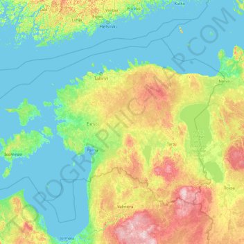
Name: Estonia topographic map, elevation, terrain.
Location: Estonia (57.50933 21.38261 59.93833 28.21002)
Average elevation: 38 m
Minimum elevation: -3 m
Maximum elevation: 270 m
Estonia lies on the eastern shores of the Baltic Sea immediately across the Gulf of Finland, on the level northwestern part of the East European Plain between 57.3° and 59.5° N and 21.5° and 28.1° E. Average elevation reaches only 50 metres (164 ft) and the country's highest point is the Suur Munamägi in the southeast at 318 metres (1,043 ft). There are 3,794 kilometres (2,357 mi) of coastline marked by numerous bays, straits, and inlets. Estonia's number of islands and islets in the Baltic Sea is estimated at some 2,222, and the country has 2,355 including those in lakes. Two of them are large enough to constitute separate counties: Saaremaa and Hiiumaa. A small, recent cluster of meteorite craters, the largest of which is called Kaali, is found on Saaremaa.
Other topographic maps
Click on a map to view its topography, its elevation and its terrain.
Ireland
Ireland
Average elevation: 44 m
Chasiv Yar
Chasiv Yar, Chasiv Yar urban hromada, Bakhmut Raion, Donetsk Oblast, 84551-84556, Ukraine
Average elevation: 213 m
Cork
Ireland > County Cork > Cork
Cork, County Cork, Munster, T12 T997, Ireland
Average elevation: 94 m
Europe
Europe
Average elevation: 223 m
Croatia
Croatia
Average elevation: 323 m
Bain-de-Bretagne
France > Brittany > Ille-et-Vilaine
Bain-de-Bretagne, Redon, Ille-et-Vilaine, Brittany, Metropolitan France, 35470, France
Average elevation: 70 m
Czechia
Czechia
Average elevation: 369 m
Bangladesh
Bangladesh
Average elevation: 161 m
Toliara
Toliara, Atsimo-Andrefana, Province de Toliara, 601, Madagascar
Average elevation: 38 m
Nacogdoches County
Nacogdoches County, Texas, United States
Average elevation: 93 m
Taiwan
Taiwan > Taiwan Province > Xinyi Township
Taiwan, Xinyi Township, Nantou County, Taiwan Province, Taiwan
Average elevation: 196 m
Fort Severn
Canada > Ontario > Kenora District
Fort Severn, Kenora District, Northwestern Ontario, Ontario, Canada
Average elevation: 11 m
Višegrad
Bosnia and Herzegovina > Republika Srpska
Višegrad, Visegrad municipality, Republika Srpska, 73240, Bosnia and Herzegovina
Average elevation: 562 m
Stone Canyon Reservoir & Watershed
United States > California > Los Angeles
Stone Canyon Reservoir & Watershed, Bel Air Road, Beverly Glen, Los Angeles, California, 90077, United States
Average elevation: 341 m
Tooele County
United States of America > Utah
Tooele County, Utah, United States of America
Average elevation: 1,462 m
El Dorado County
El Dorado County, California, United States
Average elevation: 1,286 m
High Wycombe
United Kingdom > England > Buckinghamshire
High Wycombe, Buckinghamshire, England, United Kingdom
Average elevation: 124 m
Barton-upon-Humber
United Kingdom > England > North Lincolnshire
Barton-upon-Humber, North Lincolnshire, England, DN18 5QP, United Kingdom
Average elevation: 24 m
Kilnaleck
Kilnaleck, Ballyjamesduff Municipal District, County Cavan, A82 X567, Ireland
Average elevation: 114 m
Galway City
Galway, Galway City, County Galway, Connacht, H91 YD86, Ireland
Average elevation: 26 m
Madagascar
Madagascar
Average elevation: 139 m
El Salvador
El Salvador
Average elevation: 484 m
Kilmihil
Kilmihil, West Clare Municipal District, County Clare, Munster, Ireland
Average elevation: 69 m
Newquay
Newquay, Abbey ED, West Clare Municipal District, County Clare, Munster, Ireland
Average elevation: 7 m
Nasugbu
Nasugbu, Batangas, Calabarzon, 4231, Philippines
Average elevation: 71 m
Monterey County
Monterey County, California, United States
Average elevation: 282 m
Victorville
United States > California > San Bernardino County
Victorville, San Bernardino County, California, United States
Average elevation: 920 m
Lausanne
Switzerland > Vaud > District de Lausanne
Lausanne, District de Lausanne, Vaud, Switzerland
Average elevation: 621 m
Toblach - Dobbiaco
Italy > Trentino – Alto Adige/Südtirol > South Tyrol
Toblach - Dobbiaco, Pustertal - Val Pusteria, South Tyrol, Trentino – Alto Adige/Südtirol, 39034, Italy
Average elevation: 1,813 m
Great Kei Local Municipality
South Africa > Eastern Cape > Amathole District Municipality
Great Kei Local Municipality, Amathole District Municipality, Eastern Cape, South Africa
Average elevation: 295 m
Unity
United States > Maine > Waldo County
Unity, Waldo County, Maine, United States
Average elevation: 95 m
Krishnapur
India > Maharashtra > Chandurbazar
Krishnapur, Chandurbazar, Amravati District, Maharashtra, India
Average elevation: 348 m