
Make a donation
Gear up for your next adventure:
As an Amazon Associate, this site earns from qualifying purchases at no extra cost to you.
Dodge County topographic map
Click on the map to display elevation.
Make a donation
Gear up for your next adventure:
As an Amazon Associate, this site earns from qualifying purchases at no extra cost to you.
Dodge County
The Heart of Georgia Regional Airport is located three miles east of Eastman off of State Route 46. Elevation 304'. Runway 02/20 is 6,506'x100'and has a precision instrument landing system. The airport is owned by the Heart of Georgia Regional Airport Authority and is home to the Middle Georgia State College Georgia Aviation campus. Middle Georgia State College operates the Federal Aviation Administration's #1 ranked student control tower in the United States. Other businesses at the airport include aircraft manufacturing, aircraft metal finishing, and general metal fabrication. The airport's fixed-base operator is located in the terminal building midfield. The terminal building is named after W. S. Stuckey Sr., founder of Stuckey's Candy Company (now Standard Candy) an aviation pioneer who is from Eastman.
Make a donation
Gear up for your next adventure:
As an Amazon Associate, this site earns from qualifying purchases at no extra cost to you.
About this map
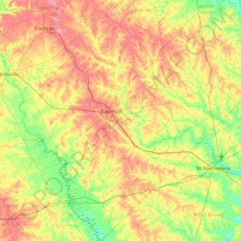
Name: Dodge County topographic map, elevation, terrain.
Location: Dodge County, Georgia, United States (31.90071 -83.37412 32.45243 -82.85804)
Average elevation: 84 m
Minimum elevation: 40 m
Maximum elevation: 141 m
Make a donation
Gear up for your next adventure:
As an Amazon Associate, this site earns from qualifying purchases at no extra cost to you.
Other topographic maps
Click on a map to view its topography, its elevation and its terrain.
Make a donation
Gear up for your next adventure:
As an Amazon Associate, this site earns from qualifying purchases at no extra cost to you.
Flint River Dam
United States > Georgia > Dougherty County > Albany > Lakeside
Average elevation: 61 m
Make a donation
Gear up for your next adventure:
As an Amazon Associate, this site earns from qualifying purchases at no extra cost to you.
Atlanta
United States > Georgia > Fulton County
Atlanta (/ætˈlæntə/ at-LAN-tə) is the capital and most populous city of the U.S. state of Georgia. It lies primarily within Fulton County (for which it serves as county seat), with about 10% of the city lying within neighboring DeKalb County. With a population of 498,715 living within the city limits, it…
Average elevation: 285 m
Make a donation
Gear up for your next adventure:
As an Amazon Associate, this site earns from qualifying purchases at no extra cost to you.