
Chicxulub crater topographic map
Interactive map
Click on the map to display elevation.
About this map
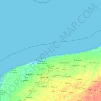
Name: Chicxulub crater topographic map, elevation, terrain.
Location: Chicxulub crater, Mexico (20.58387 -90.39090 22.21155 -88.64265)
Average elevation: 4 m
Minimum elevation: -4 m
Maximum elevation: 31 m
Other topographic maps
Click on a map to view its topography, its elevation and its terrain.
Oaxaca
The state of Oaxaca is located in Southeastern Mexico, bordered by the states of Puebla, Veracruz, Chiapas and Guerrero, with the Pacific Ocean to the south. It has a territory of 93,967 km2 (36,281 sq mi), accounting for less than 5% of Mexico's territory. Here several mountain chains come together, with the…
Average elevation: 714 m
Mexico City
The majority of Mexican central and northern territories are located at high altitudes, and as such the highest elevations are found at the Trans-Mexican Volcanic Belt which crosses Mexico east to west: Pico de Orizaba (5,700 m or 18,701 ft), Popocatépetl (5,462 m or 17,920 ft) and Iztaccihuatl (5,286 m or…
Average elevation: 2,344 m
Ojo de Agua
Mexico > State of Mexico > Tecámac
Ojo de Agua is the largest colonia in the municipality of Tecámac in State of Mexico, Mexico. It is located in the northeastern part of the state, northeast of Mexico City and within the Greater Mexico City urban area. It had a 2010 census population of 242,272 inhabitants, or 66.45 percent of its…
Average elevation: 2,297 m
Veracruz
The natural geography can be categorized into nine regions: The Sierra de Zongolica, the Tecolutla Region, the Huayacocotla Region, the Metlac River area, the Tuxtlas Region, the Central Region, the Laguna del Castillo Region, the Pueblo Viejo-Tamiahua Region and the Laguna de Alvarado Region. The topography…
Average elevation: 653 m
Atlixco
The city of Atlixco is in the west of the state of Puebla at an elevation of 1,881 meters above sea level, 25 km from the state capital of Puebla. The main economic activities of the city are agriculture and basic commerce. It lies at the foot of the Cerro de San Miguel mountain, which is the main geographical…
Average elevation: 1,873 m
Pinal de Amoles
The Puerta del Cielo (Door of Heaven) is an area just off Highway 120. The area is in forests of pine, cedar and white cedar. In the upper part, there is a chapel to the Virgin Mary with the inscription of “Virgen María Puerta del Cielo” (Virgin Mary Door of Heaven), from which the name is derived. This…
Average elevation: 1,606 m
Zapopan
Most of the municipality is flat with another quarter having rolling hills. Altitude varies from 1,500 to 2,000 metres (4,900 to 6,600 ft) above sea level. The main elevations are in the Sierra de la Primavera and include Nejahuete, Tajo and El Chapulin. Superficial water flows mostly in arroyos east to the…
Average elevation: 1,586 m
Cherán
Cherán (Spanish pronunciation: [tʃe'ɾan]) is a municipality located in the Mexican state of Michoacán, which is situated in the central western portion of Mexico, extending west to the Pacific Shore. Cherán itself lies in the northwestern portion of Michoacán, about 360 km (220 mi) west of Mexico City…
Average elevation: 2,425 m
Tlalpan
Much of the geology of the area formed when the Xitle volcano erupted in 100 CE, which created numerous caves and formed the basis of the volcanic soil that, 600 years later, makes the area's agriculture so productive. The borough has two types of soil: rocky in higher elevations and—in lower areas—less…
Average elevation: 2,833 m
Michoacán
Much of the climate of the state is determined by altitude and other geographical features. Average temperatures vary from 13 °C (55 °F) to 29 °C (84 °F). Lower temperatures correspond with the highland areas in the north and east while the lower south and west, called La Costa (the coast) or Tierra…
Average elevation: 1,239 m
Guadalajara
Under the Köppen climate classification, Guadalajara has a humid subtropical climate (Cwa), a temperate climate that is quite close to a tropical climate, featuring dry warm winters and wet, mildly hot summers. Guadalajara's climate is influenced by its high altitude and the general seasonality of…
Average elevation: 1,543 m
Puebla
Most of the mountains of Puebla belong to the Sierra Madre Oriental and the Trans-Mexican Volcanic Belt. The first is locally called the Sierra Norte del Puebla, entering the state from the northwest and then breaks up into the smaller chains of Sierra de Zacapoaxtla, Sierra de Huauchinango, Sierra de…
Average elevation: 1,532 m
Nayarit
Nayarit's natural vegetation varies with altitude; coastal lowlands and river valleys were, historically, covered with tropical dry forest, containing many native deciduous trees that lost their leaves during the dry seasons. The Sinaloan dry forests now cover the northern coastal lowlands, and extend up the…
Average elevation: 834 m
Jalisco
Jalisco is made up of a diverse terrain that includes forests, beaches, plains, and lakes. Altitudes in the state vary from 0 to 4,300 meters (0 to 14,110 ft) above sea level, from the coast to the top of the Nevado de Colima. The Jalisco area contains all five of Mexico's natural ecosystems: arid and semi…
Average elevation: 1,301 m
Coahuila
The Sierra Madre Oriental runs northwest to southeast through the State, and the higher elevations are home to the Sierra Madre Oriental pine-oak forests. The northernmost fingers of the Sierra Madre Oriental, the Sierra del Burro and the Sierra del Carmen, reach to the border with the United States at the Rio…
Average elevation: 1,009 m
Baja California Sur
The climate of the state is dry, with an average annual temperature of 18–22 °C and average annual rainfall of less than 200mm. The lower elevations are the driest and hottest, with summer daytime temperatures above 40 °C; wintertime temperatures may fall below freezing. The exception to desert conditions…
Average elevation: 90 m
Morelos
Morelos, most of which is between 1,000 and 3,300 meters (3,300 and 10,800 ft) above sea level, has a very diverse topography: 42% is mountainous, 16% hilly land, and 42% flat terrain. The highest altitudes are found near the state's border with Mexico City, and the lowest are found in the Huaxtla region. The…
Average elevation: 1,642 m
Querétaro
Mexico > Querétaro > Querétaro
Three of Mexico’s geographic zones cover parts of the state. The Mesa del Centro is in the center-west of the state, and mostly consists of small mesas with an average altitude of 2,000 meters (6,562 feet) above sea level (ASL). A few elevations reach over 3,000 meters (9,843 feet). The Sierra Madre Oriental…
Average elevation: 1,965 m
Mexico City
Mexico City (Spanish: Ciudad de México, locally [sjuˈða(ð) ðe ˈmexiko] (listen); abbr.: CDMX; Nahuatl: Āltepētl Mēxihco Nahuatl pronunciation: [ɑːl'tɛpeːt͡ɬ meːʃi'ko]) is the capital and largest city of Mexico, and the most populous city in North America. One of the world's alpha cities, it is…
Average elevation: 2,619 m
La Paz
Mexico > State of Mexico > La Paz
The city, in west-central Bolivia 68 km (42 mi) southeast of Lake Titicaca, is set in a canyon created by the Choqueyapu River. It is in a bowl-like depression, part of the Amazon basin, surrounded by the high mountains of the Altiplano. Overlooking the city is the towering, triple-peaked Illimani. Its peaks…
Average elevation: 2,324 m
Ciudad Constitución
Mexico > Baja California Sur > Municipio de Comondú > Ciudad Constitución
Average elevation: 54 m