
Nayarit topographic map
Interactive map
Click on the map to display elevation.
Nayarit
Nayarit's natural vegetation varies with altitude; coastal lowlands and river valleys were, historically, covered with tropical dry forest, containing many native deciduous trees that lost their leaves during the dry seasons. The Sinaloan dry forests now cover the northern coastal lowlands, and extend up the valleys of the San Pedro Mezquital River and the Río Grande de Santiago and its tributaries. The Jalisco dry forests ecoregion covers coastal Nayarit south of San Blas and the Islas Marías.
About this map
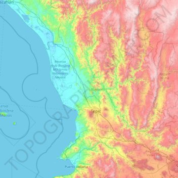
Name: Nayarit topographic map, elevation, terrain.
Location: Nayarit, Mexico (20.60322 -106.70322 23.08450 -103.72090)
Average elevation: 834 m
Minimum elevation: -2 m
Maximum elevation: 3,202 m
Other topographic maps
Click on a map to view its topography, its elevation and its terrain.
Ojo de Agua
Mexico > State of Mexico > Tecámac
Ojo de Agua is the largest colonia in the municipality of Tecámac in State of Mexico, Mexico. It is located in the northeastern part of the state, northeast of Mexico City and within the Greater Mexico City urban area. It had a 2010 census population of 242,272 inhabitants, or 66.45 percent of its…
Average elevation: 2,297 m
Atlixco
The city of Atlixco is in the west of the state of Puebla at an elevation of 1,881 meters above sea level, 25 km from the state capital of Puebla. The main economic activities of the city are agriculture and basic commerce. It lies at the foot of the Cerro de San Miguel mountain, which is the main geographical…
Average elevation: 1,873 m
Querétaro
Mexico > Querétaro > Querétaro
Three of Mexico’s geographic zones cover parts of the state. The Mesa del Centro is in the center-west of the state, and mostly consists of small mesas with an average altitude of 2,000 meters (6,562 feet) above sea level (ASL). A few elevations reach over 3,000 meters (9,843 feet). The Sierra Madre Oriental…
Average elevation: 1,965 m
Ciudad Constitución
Mexico > Baja California Sur > Municipio de Comondú > Ciudad Constitución
Average elevation: 54 m