
Arroyo Seco topographic map
Interactive map
Click on the map to display elevation.
About this map
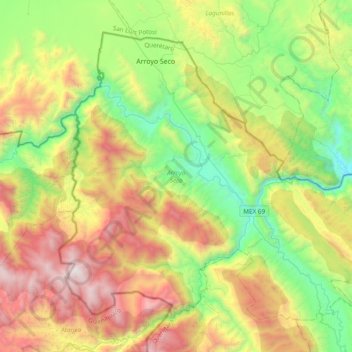
Name: Arroyo Seco topographic map, elevation, terrain.
Location: Arroyo Seco, Querétaro, Mexico (21.28607 -99.79452 21.57836 -99.41116)
Average elevation: 1,264 m
Minimum elevation: 394 m
Maximum elevation: 2,667 m
Other topographic maps
Click on a map to view its topography, its elevation and its terrain.
Querétaro
Mexico > Querétaro > Querétaro
Three of Mexico’s geographic zones cover parts of the state. The Mesa del Centro is in the center-west of the state, and mostly consists of small mesas with an average altitude of 2,000 meters (6,562 feet) above sea level (ASL). A few elevations reach over 3,000 meters (9,843 feet). The Sierra Madre Oriental…
Average elevation: 1,965 m