
Saluen topographic map
Interactive map
Click on the map to display elevation.
About this map
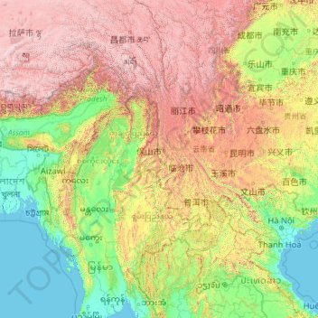
Name: Saluen topographic map, elevation, terrain.
Location: Saluen, 泸水县 (Lushui), 怒江州, Yunnan, China (16.14482 91.71541 31.56705 99.18660)
Average elevation: 1,391 m
Minimum elevation: -2 m
Maximum elevation: 7,070 m
Other topographic maps
Click on a map to view its topography, its elevation and its terrain.
九甲镇
China > Yunnan > 镇沅彝族哈尼族拉祜族自治县 > 九甲镇
九甲镇, 镇沅彝族哈尼族拉祜族自治县, Pu’er, Yunnan, 665000, China
Average elevation: 1,834 m
Roter Fluss
Roter Fluss, 金平苗族瑶族傣族自治县 (Jinping), 红河州:红河, Yunnan, 661300, China
Average elevation: 1,100 m
Shangri-La
China > Yunnan > Shangri-La
Shangri-La, 香格里拉市, 迪庆州, Yunnan, 674400, China
Average elevation: 3,675 m