
Tengchong topographic map
Interactive map
Click on the map to display elevation.
About this map
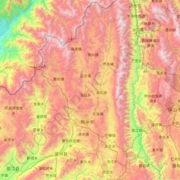
Name: Tengchong topographic map, elevation, terrain.
Location: Tengchong, Baoshan, Yunnan, 679100, China (24.62636 98.08895 25.85988 98.77228)
Average elevation: 1,830 m
Minimum elevation: 174 m
Maximum elevation: 3,717 m
Der Kreis liegt auf 1.655 m Höhe über NN und ist einer der Endpunkte der Heihe-Tengchong-Linie, die in Heihe (in der Provinz Heilongjiang) beginnt. Er hat eine Fläche von 5.710 km² und 642.481 Einwohner (Stand: Zensus 2020).