
Make a donation
Gear up for your next adventure:
As an Amazon Associate, this site earns from qualifying purchases at no extra cost to you.
Aghsu topographic map
Click on the map to display elevation.
Make a donation
Gear up for your next adventure:
As an Amazon Associate, this site earns from qualifying purchases at no extra cost to you.
About this map
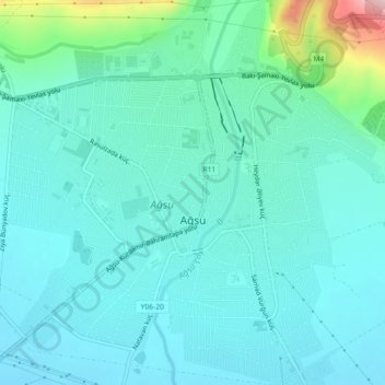
Name: Aghsu topographic map, elevation, terrain.
Location: Aghsu, Agsu District, Azerbaijan (40.55331 48.37207 40.58740 48.41713)
Average elevation: 186 m
Minimum elevation: 139 m
Maximum elevation: 415 m
Make a donation
Gear up for your next adventure:
As an Amazon Associate, this site earns from qualifying purchases at no extra cost to you.
Other topographic maps
Click on a map to view its topography, its elevation and its terrain.
Lankaran-Astara
Lankaran economic region has diverse soil cover. In the Lankaran lowland, glacial-yellow soil is dominant. But the plains-foothill zone of the region is covered with forest soil. In the Talysh mountains, the brown mountain-forest and mountain meadowlands are spread. The brown mountain-forest lands are formed…
Average elevation: 385 m
Make a donation
Gear up for your next adventure:
As an Amazon Associate, this site earns from qualifying purchases at no extra cost to you.
Sheki District
The elevation of 500–850 m above sea level, the mountain woodlands encompassing it prevents the city from overheating. The city is secured from floods by mountain woodlands. The mountainous grassland, brown mountain woodlands, meadow-forest, grey-brown soils cover the city. Oak, peanuts, hornbeam trees are…
Average elevation: 737 m
Make a donation
Gear up for your next adventure:
As an Amazon Associate, this site earns from qualifying purchases at no extra cost to you.
Jalilabad District
The territory of the district primarily consists of plains and low mountains. The altitude of some mountains in the east is below sea level. The climate is mild with dry summers. The average temperature is 1–3 °C (34–37 °F) in winter and 25–30 °C (77–86 °F) in summer. The average amount of annual…
Average elevation: 185 m
Shabran District
The greater part of the district is mountainous. The Caspian Sea is located 12 km from Shabran city. The district borders upon Quba, Khachmaz, Shamakhi and Siazan Districts. Forests occupy 27000 ha in mountainous territories and plains near the Caspian Sea and they are of great importance with their climatic…
Average elevation: 523 m
Make a donation
Gear up for your next adventure:
As an Amazon Associate, this site earns from qualifying purchases at no extra cost to you.
Goygol District
Goygol and 7 identical lakes – Maralgol, Zaligol, Aghgol, Shamligol, Ordekgol, Jeyrangol and Garagol are located in the territory of Goygol district. Lake Goygol is situated on the foothill of Mount Kapaz at an altitude of 1556 meters. The length of the lake is 2450 meters, and its width is 595 meters, the…
Average elevation: 1,217 m
Dashkasan District
The district covers the Dashkasan plateau of the Lesser Caucasian Mountain range encompassing parts and tips of Shahdagh and Murovdag ranges. The highest altitudes are at Hinaldag Peak (3,367 meters) and Qoshqar Peak (3,361 meters). Part of Bashkend-Dastafur lowlands also falls in Dashkasan rayon. This part of…
Average elevation: 1,771 m
Make a donation
Gear up for your next adventure:
As an Amazon Associate, this site earns from qualifying purchases at no extra cost to you.
Make a donation
Gear up for your next adventure:
As an Amazon Associate, this site earns from qualifying purchases at no extra cost to you.
Quba - Khachmaz
The climate of the region has special topographic characteristic with four different zones. Clime types are divided into hot in the plain zones, cold-humid and cold in the mountain zones.
Average elevation: 647 m
Make a donation
Gear up for your next adventure:
As an Amazon Associate, this site earns from qualifying purchases at no extra cost to you.
Mountainous Shirvan
The climate is semi-desert and a dry slope (Gobustan) mild warm climate with dry summers (Gurjivan '* Shamakhi - Maraza plateau), moderately warm climate with dry winters (the areas with 1000 – 1200 m altitudes in the North - Eastern slopes of Great Caucasus Mountains), temperate climate with equal…
Average elevation: 711 m
Make a donation
Gear up for your next adventure:
As an Amazon Associate, this site earns from qualifying purchases at no extra cost to you.
Make a donation
Gear up for your next adventure:
As an Amazon Associate, this site earns from qualifying purchases at no extra cost to you.
Beylagan District
Beylagan is one of the southwestern districts of Azerbaijan and situated in the Mil valley of the Kur – Araz lowland and in the middle of the Kur and Araz rivers. Geographical coordinates are 39°45’ North latitude and 47°30’ West longitude and bordering Agchabadi, Zardab, Imishli, Fuzuli districts and…
Average elevation: 58 m
Make a donation
Gear up for your next adventure:
As an Amazon Associate, this site earns from qualifying purchases at no extra cost to you.
Make a donation
Gear up for your next adventure:
As an Amazon Associate, this site earns from qualifying purchases at no extra cost to you.
Khojaly District
Khojaly district is located in Nagorno-Karabakh. The territory of the district is mountainous. The highest altitudes are Qirkhqiz and Gizgala, the main rivers are Gargar and Badara. The climate is mild-hot except the mountainous area.
Average elevation: 1,336 m
Make a donation
Gear up for your next adventure:
As an Amazon Associate, this site earns from qualifying purchases at no extra cost to you.
Make a donation
Gear up for your next adventure:
As an Amazon Associate, this site earns from qualifying purchases at no extra cost to you.
Naftalan City
Naftalan city is located 330 km west of Baku, 50 km from Ganja in the foothills of the Lesser Caucasus Mountains. It's located at an altitude of 225 m above sea level. The spring is warm, the winter is soft here. The average annual temperature is +14.8 degrees. The wind in Naftalan is mainly monsoon. The…
Average elevation: 238 m
Ismailli District
The landscape is mainly composed of mountains. Altitudes vary between 200 and 3629 meters (Babadagh) above sea level. The area is passed by the Goychay, Gyrdyman, Akhokh, Ayrichay, Sulut and other rivers, Yekekhana and Ashygbayram artificial ponds.
Average elevation: 1,009 m
Make a donation
Gear up for your next adventure:
As an Amazon Associate, this site earns from qualifying purchases at no extra cost to you.
Make a donation
Gear up for your next adventure:
As an Amazon Associate, this site earns from qualifying purchases at no extra cost to you.
Nakhchivan Autonomous Republic
The Republic is rich in minerals. Nakhchivan possesses deposits of marble, lime, and gypsum. The deposits of the rock salt are exhausted in Nehram, Nakhchivan, and Sustin. The important molybdenum mines are currently closed as a consequence of the exclave's isolation. There are a lot of mineral springs such as…
Average elevation: 1,590 m