
Dashkasan District topographic map
Interactive map
Click on the map to display elevation.
Dashkasan District
The district covers the Dashkasan plateau of the Lesser Caucasian Mountain range encompassing parts and tips of Shahdagh and Murovdag ranges. The highest altitudes are at Hinaldag Peak (3,367 meters) and Qoshqar Peak (3,361 meters). Part of Bashkend-Dastafur lowlands also falls in Dashkasan rayon. This part of the region is rich with cretaceous chalk. The average annual rainfall is 600–900 mm. It mostly rains during springtime. The mountains are enriched with oak forests.
About this map
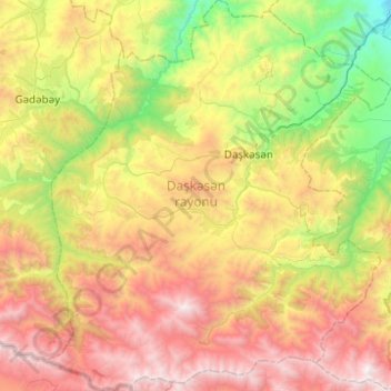
Name: Dashkasan District topographic map, elevation, terrain.
Location: Dashkasan District, Azerbaijan (40.29232 45.82314 40.66913 46.26274)
Average elevation: 1,771 m
Minimum elevation: 545 m
Maximum elevation: 3,446 m
Other topographic maps
Click on a map to view its topography, its elevation and its terrain.
Gazakh
Gazakh region is located in the western part of the republic, in the western part of the vast Ganja-Gazakh plain, which starts from the slopes of the mountain range of the Lesser Caucasus and extends along the right bank of the Kura river. The highest elevation is "Odun" mountain (1316 meters). Its nature is…
Average elevation: 382 m
Shirvan
Throughout its history, Shirvan has suffered from floods because of its proximity to the river and the relatively low elevation of most of the town.
Average elevation: 16 m
Gadabay
Gadabay lies at the northern foot of the Shahdagh Range, at an altitude of 1460 meters, on the coast of the Mis River. The city is located in the middle and high mountainous areas of the Lesser Caucasus (also called Little Caucasus).
Average elevation: 1,499 m