
Shamakhi District topographic map
Interactive map
Click on the map to display elevation.
About this map
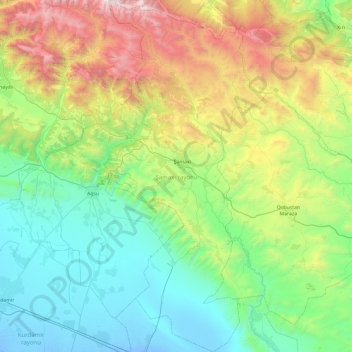
Name: Shamakhi District topographic map, elevation, terrain.
Location: Shamakhi District, 5626, Azerbaijan (40.23672 48.42435 40.96623 48.86734)
Average elevation: 726 m
Minimum elevation: -11 m
Maximum elevation: 2,825 m
Other topographic maps
Click on a map to view its topography, its elevation and its terrain.
Gazakh
Gazakh region is located in the western part of the republic, in the western part of the vast Ganja-Gazakh plain, which starts from the slopes of the mountain range of the Lesser Caucasus and extends along the right bank of the Kura river. The highest elevation is "Odun" mountain (1316 meters). Its nature is…
Average elevation: 382 m
Shirvan
Throughout its history, Shirvan has suffered from floods because of its proximity to the river and the relatively low elevation of most of the town.
Average elevation: 16 m
Gadabay
Gadabay lies at the northern foot of the Shahdagh Range, at an altitude of 1460 meters, on the coast of the Mis River. The city is located in the middle and high mountainous areas of the Lesser Caucasus (also called Little Caucasus).
Average elevation: 1,499 m