
Make a donation
Gear up for your next adventure:
As an Amazon Associate, this site earns from qualifying purchases at no extra cost to you.
Shabran District topographic map
Click on the map to display elevation.
Make a donation
Gear up for your next adventure:
As an Amazon Associate, this site earns from qualifying purchases at no extra cost to you.
Shabran District
The greater part of the district is mountainous. The Caspian Sea is located 12 km from Shabran city. The district borders upon Quba, Khachmaz, Shamakhi and Siazan Districts. Forests occupy 27000 ha in mountainous territories and plains near the Caspian Sea and they are of great importance with their climatic and natural resources for the district. The Shabran and Davachi Rivers flow through the district's territory, and the Valvalachay and Gilgilchay Rivers flow in northern and southern borders directly to the Caspian Sea. Samur-Davachi lowland has an altitude of −28 m below the world ocean level.
Make a donation
Gear up for your next adventure:
As an Amazon Associate, this site earns from qualifying purchases at no extra cost to you.
About this map
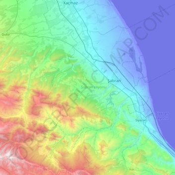
Name: Shabran District topographic map, elevation, terrain.
Location: Shabran District, Azerbaijan (40.89174 48.67286 41.47439 49.39376)
Average elevation: 523 m
Minimum elevation: -30 m
Maximum elevation: 2,686 m
Make a donation
Gear up for your next adventure:
As an Amazon Associate, this site earns from qualifying purchases at no extra cost to you.
Other topographic maps
Click on a map to view its topography, its elevation and its terrain.
Make a donation
Gear up for your next adventure:
As an Amazon Associate, this site earns from qualifying purchases at no extra cost to you.
Gadabay
Gadabay lies at the northern foot of the Shahdagh Range, at an altitude of 1460 meters, on the coast of the Mis River. The city is located in the middle and high mountainous areas of the Lesser Caucasus (also called Little Caucasus).
Average elevation: 1,499 m
Shirvan
Throughout its history, Shirvan has suffered from floods because of its proximity to the river and the relatively low elevation of most of the town.
Average elevation: 16 m
Make a donation
Gear up for your next adventure:
As an Amazon Associate, this site earns from qualifying purchases at no extra cost to you.
Gazakh
Gazakh region is located in the western part of the republic, in the western part of the vast Ganja-Gazakh plain, which starts from the slopes of the mountain range of the Lesser Caucasus and extends along the right bank of the Kura river. The highest elevation is "Odun" mountain (1316 meters). Its nature is…
Average elevation: 382 m
Make a donation
Gear up for your next adventure:
As an Amazon Associate, this site earns from qualifying purchases at no extra cost to you.