
Canary Islands topographic map
Interactive map
Click on the map to display elevation.
About this map
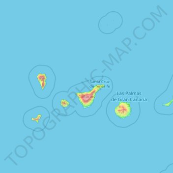
Name: Canary Islands topographic map, elevation, terrain.
Location: Canary Islands, Spain (27.63774 -18.16087 29.41606 -13.33201)
Average elevation: 16 m
Minimum elevation: 0 m
Maximum elevation: 3,500 m
The Canary Islands, especially Tenerife, Gran Canaria, Fuerteventura, and Lanzarote, are a major tourist destination, with over 12 million visitors per year. This is due to their beaches, subtropical climate, and important natural attractions, especially Maspalomas in Gran Canaria and Mount Teide (a World Heritage Site) in Tenerife. Mount Teide is the highest peak in Spain and the third tallest volcano in the world, measured from its base on the ocean floor. The islands have warm summers and winters warm enough for the climate to be technically tropical at sea level. The amount of precipitation and the level of maritime moderation vary depending on location and elevation. The archipelago includes green areas as well as desert. The islands' high mountains are ideal for astronomical observation, because they lie above the temperature inversion layer. As a result, the archipelago boasts two professional observatories: Teide Observatory on Tenerife, and Roque de los Muchachos Observatory on La Palma.
Other topographic maps
Click on a map to view its topography, its elevation and its terrain.
Valencia
Spain > Valencian Community > Comarca de València
Valencia, Comarca de València, Valencia, Valencian Community, Spain
Average elevation: 37 m
Monte de El Pardo
Monte de El Pardo, Community of Madrid, Spain
Average elevation: 689 m
Belchite
Spain > Aragon > Campo de Belchite
Belchite, Campo de Belchite, Zaragoza, Aragon, 50130, Spain
Average elevation: 467 m
Teruel
Spain > Aragon > Comunidad de Teruel
Teruel, Comunidad de Teruel, Teruel, Aragon, Spain
Average elevation: 1,118 m
Parc Natural del Delta de l'Ebre
Spain > Catalonia > Montsià > Amposta
Parc Natural del Delta de l'Ebre, Amposta, Montsià, Tarragona, Catalonia, 43870, Spain
Average elevation: 40 m
Sant Boi de Llobregat
Spain > Catalonia > Baix Llobregat
Sant Boi de Llobregat, Baix Llobregat, Barcelona, Catalonia, 08830, Spain
Average elevation: 34 m
Villarluengo
Spain > Aragon > Maestrazgo
Villarluengo, Maestrazgo, Teruel, Aragon, Spain
Average elevation: 1,265 m
Morella
Morella, els Ports, Castelló / Castellón, Valencian Community, Spain
Average elevation: 949 m
Utrillas
Spain > Aragon > Cuencas Mineras
Utrillas, Cuencas Mineras, Teruel, Aragon, 44760, Spain
Average elevation: 1,159 m
La Zoma
Spain > Aragon > Cuencas Mineras
La Zoma, Cuencas Mineras, Teruel, Aragon, Spain
Average elevation: 1,256 m
Forcall
Forcall, els Ports, Castelló / Castellón, Valencian Community, 12310, Spain
Average elevation: 854 m
San Sebastián
Spain > Autonomous Community of the Basque Country
San Sebastián, Gipuzkoa, Autonomous Community of the Basque Country, Spain
Average elevation: 120 m
Tres Mojones
Spain > Castile and León > Riocavado de la Sierra
Tres Mojones, Riocavado de la Sierra, Burgos, Castile and León, Spain
Average elevation: 1,753 m
Ubrique
Spain > Andalusia > Sierra de Cádiz
Ubrique, Sierra de Cádiz, Cádiz, Andalusia, 11600, Spain
Average elevation: 612 m
Barcelona
Spain > Catalonia > Barcelonès
Barcelona, Barcelonès, Barcelona, Catalonia, 08001, Spain
Average elevation: 65 m
Churriana
Spain > Andalusia > Málaga-Costa del Sol > Málaga
Churriana, Málaga, Málaga-Costa del Sol, Malaga, Andalusia, Spain
Average elevation: 51 m
Felanitx
Spain > Balearic Islands > Migjorn
Felanitx, Migjorn, Balearic Islands, Spain
Average elevation: 101 m
San Juan del Monte
San Juan del Monte, Burgos, Castile and León, Spain
Average elevation: 872 m
Calp
Calp, la Marina Alta, Alacant / Alicante, Valencian Community, 03710, Spain
Average elevation: 89 m
Partaloa
Spain > Andalusia > Valle del Almanzora
Partaloa, Valle del Almanzora, Almeria, Andalusia, Spain
Average elevation: 620 m
Montjuïc
Spain > Catalonia > Barcelonès > Barcelona
Montjuïc, Barcelona, Barcelonès, Barcelona, Catalonia, 08001, Spain
Average elevation: 39 m
Loma de Piedra Junquera
Spain > Andalusia > Valle del Almanzora > Sierro
Loma de Piedra Junquera, Sierro, Valle del Almanzora, Almeria, Andalusia, Spain
Average elevation: 1,501 m
Sanlúcar de Barrameda
Spain > Andalusia > Northwest Coast
Sanlúcar de Barrameda, Northwest Coast, Cádiz, Andalusia, Spain
Average elevation: 11 m
Santiago de la Espada
Spain > Andalusia > Santiago-Pontones
Santiago de la Espada, Santiago-Pontones, Jaén, Andalusia, Spain
Average elevation: 1,383 m
Huelva
Spain > Andalusia > Comarca Metropolitana de Huelva
Huelva, Comarca Metropolitana de Huelva, Huelva, Andalusia, Spain
Average elevation: 22 m
Benalmádena
Spain > Andalusia > Costa del Sol Occidental
Benalmádena, Costa del Sol Occidental, Malaga, Andalusia, Spain
Average elevation: 276 m
El Escorial
El Escorial, Community of Madrid, Spain
Average elevation: 1,057 m
Álava
Spain > Autonomous Community of the Basque Country
Álava, Autonomous Community of the Basque Country, Spain
Average elevation: 597 m