
Madagascar topographic map
Interactive map
Click on the map to display elevation.
Madagascar
Along the length of the eastern coast runs a narrow and steep escarpment containing much of the island's remaining tropical lowland forest. To the west of this ridge lies a plateau in the center of the island ranging in altitude from 750 to 1,500 m (2,460 to 4,920 ft) above sea level. These central highlands, traditionally the homeland of the Merina people and the location of their historic capital at Antananarivo, are the most densely populated part of the island and are characterized by terraced, rice-growing valleys lying between grassy hills and patches of the subhumid forests that formerly covered the highland region. To the west of the highlands, the increasingly arid terrain gradually slopes down to the Mozambique Channel and mangrove swamps along the coast.
About this map
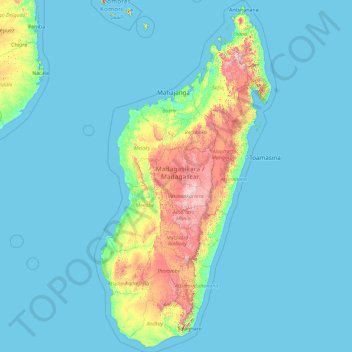
Name: Madagascar topographic map, elevation, terrain.
Location: Madagascar (-25.78402 42.96801 -11.73289 50.67273)
Average elevation: 139 m
Minimum elevation: -1 m
Maximum elevation: 2,568 m
Other topographic maps
Click on a map to view its topography, its elevation and its terrain.
Tbilisi
Most of the raions are named after historic quarters of the city. The citizens of Tbilisi widely recognise an informal system of smaller historic neighbourhoods. Such neighbourhoods are several, however, constituting a kind of hierarchy, because most of them have lost their distinctive topographic limits. The…
Average elevation: 713 m
Big Sur
United States > California > Monterey County
The highest peaks of the crest of the coast range are located at an average distance from the coast of three and a half miles [5.6 km]. In this distance they rise to elevations of from three thousand six hundred to five thousand feet [1,100 to 1,500 m] above the sea-level. From San Carpoforo Creek to…
Average elevation: 193 m
Svinjašnica
Bosnia and Herzegovina > Federation of Bosnia and Herzegovina > Town of Zavidovići
Average elevation: 446 m
Vredefort
South Africa > Free State > Fezile Dabi District Municipality > Ngwathe Local Municipality
Average elevation: 1,430 m
Country Club Estates
United States > North Carolina > Alamance County > Burlington
Average elevation: 195 m
Europe
Europe's topography is characterized by a striking contrast between its rugged southern mountains and the expansive plains of the north. The continent is often described as a "peninsula of peninsulas," featuring major peninsulas like the Iberian, Italian, and Balkan, each with unique geological features. In…
Average elevation: 223 m
Tankovoye
Ukraine > Republic of Crimea > Bakhchysarai Raion > Куйбышевское сельское поселение
Average elevation: 169 m
Toowoomba
The city occupies the edge of the range and the low ridges behind it. Two valleys run north from the southern boundary, each arising from springs either side of Middle Ridge near Spring Street at an altitude of around 680 m. These waterways, East Creek and West Creek, flow together just north of the CBD to…
Average elevation: 458 m
Tassili n'Ajjer
Tassili n'Ajjer lies within the West Saharan montane xeric woodlands ecoregion. Due to the higher elevation of the area, coupled with the water-retentive properties of the sandstone, the vegetation here is somewhat more lush and verdant than in the lower regions of desert; in turn, this creates an attractive…
Average elevation: 842 m
Monument
United States > Colorado > El Paso County
Monument experiences a hemiboreal continental climate (Köppen Dfb) with warm, relatively rainy summers and cold, snowy winters. The semi-arid climate keeps the dew point very low in Monument year-round which causes the air to feel quite dry. Monument is part of the Front Range urban corridor and lies on the…
Average elevation: 2,160 m
Croydon
Several apartment developments, for instance Altitude 25 (completed 2010), have been built in recent years, and several more are being built or planned. The construction of Saffron Square, which includes a 43-storey tower, began on Wellesley Road in 2011 and was completed in 2016. Other developments with…
Average elevation: 70 m
Reigate
United Kingdom > England > Surrey > Reigate and Banstead
Reigate is in central Surrey, around 19 mi (30 km) south of central London and 9 mi (14 km) north of Gatwick Airport. The town is in the Vale of Holmesdale, below the North Downs escarpment. The average elevation in the centre is 80 m (260 ft) above ordnance datum (OD) and the area is drained by the Wallace…
Average elevation: 100 m
Harare
Harare (/həˈrɑːreɪ/; formerly Salisbury /ˈsɔːlzbəri/) is the capital and most populous city of Zimbabwe. The city proper has an area of 940 km2 (371 mi2) and a population of 2.12 million in the 2012 census and an estimated 3.12 million in its metropolitan area in 2019. Situated in north-eastern…
Average elevation: 1,470 m
Pacific Ocean
Average elevation: 0 m
Mount Kosciuszko
Mount Kosciuszko (/ˌkɒziˈʌskoʊ/ KOZ-ee-USK-oh; Polish pronunciation: [kɔɕˈt͡ɕuʂ.kɔ] kosh-CHOOSH-koh; Ngarigo: Kunama Namadgi) is the highest mountain of the mainland Australia, at 2,228 metres (7,310 ft) above sea level. It is located on the Main Range of the Snowy Mountains in Kosciuszko National…
Average elevation: 2,035 m
Antipolo
Its higher elevation than that of Metro Manila affords it a scenic view of the metropolis, especially at night. Its locally grown mangoes and cashews are popular among tourists, as well as suman – a local delicacy made out of glutinous rice. The Hinulugang Taktak National Park, which was once a popular…
Average elevation: 125 m
Three Kings Deer
United Kingdom > England > Lincolnshire > North Kesteven > Threekingham
Average elevation: 24 m
Farnsworth
United States > Texas > Ochiltree County
Farnsworth is a census designated place in western Ochiltree County, Texas, United States. It lies at the intersection of State Highway 15 with FM376, southwest of the city of Perryton, the county seat of Ochiltree County. Its elevation is 2,995 feet (913 m). Although Farnsworth is unincorporated, it has a…
Average elevation: 913 m
Glenora
Canada > British Columbia > Cowichan Valley Regional District > Area E (Cowichan Station / Sahtlam / Glenora)
Average elevation: 80 m
Eiger
Switzerland > Bern > Interlaken-Oberhasli administrative district > Grindelwald
Average elevation: 2,944 m
Malvern
United Kingdom > England > Worcestershire > Malvern Hills
Malvern lies in the Lower Severn/Avon plain affording it a degree of shelter caused by virtue of its nestling in between the Cotswold hills to the east, the Welsh Hills and Mountains to the west, and Birmingham plateau to the north. Although as with all the British Isles it has a maritime climate, the local…
Average elevation: 95 m
Celebes Sea
Average elevation: 0 m
Thor Peak
Canada > Nunavut > Qikiqtaaluk Region
Mount Thor, officially gazetted as Thor Peak (Inuktitut syllabics: ᙯᕐᓱᐊᓗᒃ, Inuktitut: Qaisualuk "huge bedrock", or Kigutinnguaq "tooth-like"), in Nunavut, Canada, is a mountain with an elevation of 1,675 m (5,495 ft) located in Auyuittuq National Park, on Baffin Island. The mountain is located 46…
Average elevation: 690 m
Pico da Neblina
Brazil > Amazonas > Santa Isabel do Rio Negro
For 39 years, based on an uncontested measurement performed in 1965 by topographer José Ambrósio de Miranda Pombo, using a theodolite, the elevation of Pico da Neblina was thought to be 3,014 metres (9,888 ft), but a much more accurate measurement performed in 2004 with state-of-the-art GPS equipment by…
Average elevation: 2,178 m