
Barisal Division topographic map
Interactive map
Click on the map to display elevation.
About this map
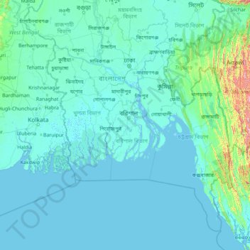
Name: Barisal Division topographic map, elevation, terrain.
Location: Barisal Division, Bangladesh (19.92606 87.69882 25.12606 92.89882)
Average elevation: 53 m
Minimum elevation: -3 m
Maximum elevation: 1,999 m
Other topographic maps
Click on a map to view its topography, its elevation and its terrain.
Camp 10
Bangladesh > Chattogram Division > Rohingya Refugee Camp in Bangladesh
Average elevation: 12 m
Sylhet District
Sylhet has a typical Bangladeshi tropical monsoon climate (Köppen Am) bordering on a humid subtropical climate (Cwa) at higher elevations. The rainy season starts from April to October and it is so hot and humid with very heavy showers and thunderstorms almost every day, whilst the short dry season starts…
Average elevation: 105 m
Brahmaputra River
Bangladesh > Mymensingh Division > Jamalpur Sadar Upazila > Jamalpur
The course of the Brahmaputra River has changed drastically in the past two and a half centuries, moving its river course westwards for a distance of about 80 km (50 mi), leaving its old river course, appropriately named the old Brahmaputra river, behind. In the past, the floodplain of the old river course had…
Average elevation: 18 m
Sylhet Division
The name Sylhet is an anglicisation of Shilhot (শিলহট). Its origins seem to come from the Sanskrit words শিলা śilā (meaning 'stone') and হট্ট haṭṭa (meaning 'marketplace'). These words match the landscape and topography of the hilly region. The shila stones were abundant across…
Average elevation: 88 m
Manikganj Sadar Subdistrict
Bangladesh > Dhaka Division > Manikganj Sadar Subdistrict
Average elevation: 8 m