
Sylhet Division topographic map
Interactive map
Click on the map to display elevation.
Sylhet Division
The name Sylhet is an anglicisation of Shilhot (শিলহট). Its origins seem to come from the Sanskrit words শিলা śilā (meaning 'stone') and হট্ট haṭṭa (meaning 'marketplace'). These words match the landscape and topography of the hilly region. The shila stones were abundant across Sylhet and King Gour Govinda is known to have used stones to guard his capital. The word changed to Shilhot due to the elision of letter-final অ ô in the Bengali language. Another theory is that it was named after Princess Sheela, the eldest daughter of Raja Guhak of the Jaintia Kingdom. It is said that Sheela was once bathing in a pond and was kidnapped. After being rescued by her father Raja Guhak, Sheela started to become more religious and live a secluded life. Sheela's died at a young age, the port-area which developed around the lake, which was the largest centre in northeastern Bengal for trade, was named Sheela haat (or Sheela's marketplace) in her honour. Xuanzang of China mentions that he visited a place called Sheelachatal in the 630s in his book, the Great Tang Records on the Western Regions. The Hattanath Tales mention Sheelachatal was named after both daughters of Guhak; Sheela and Chatala. Chatala indulged herself in an unlawful relationship with one of the palace servants, leading to her being disowned and dumped in a distant island in the middle of 2000 square mile lake to the south of the kingdom.
About this map
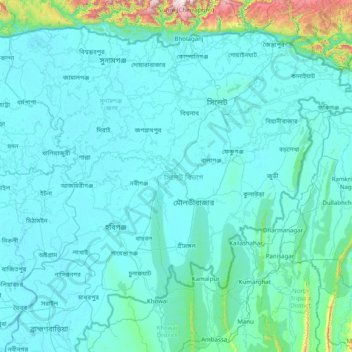
Name: Sylhet Division topographic map, elevation, terrain.
Location: Sylhet Division, Bangladesh (23.97438 90.91236 25.20735 92.49944)
Average elevation: 88 m
Minimum elevation: 0 m
Maximum elevation: 1,620 m
Other topographic maps
Click on a map to view its topography, its elevation and its terrain.
Sajek Valley - সাজেক ভ্যালি / মেঘের উপত্যকায় জীবন
Bangladesh > Chattogram Division > Bagaichhari Upazila > Sajek
Average elevation: 256 m
Rangamati
Bangladesh > Chattogram Division > Rangamati Sadar Upazila
Rangamati (Bengali: রাঙ্গামাটি is the administrative headquarter and town of Rangamati District in the Chittagong Hill Tracts of Bangladesh. The town is located at 22°37'60N 92°12'0E and has an altitude of 14 metres (46 ft). It was the capital of the Chakma kingdom during the British rule…
Average elevation: 68 m
Brahmaputra River
Bangladesh > Mymensingh Division > Jamalpur Sadar Upazila > Jamalpur
The course of the Brahmaputra River has changed drastically in the past two and a half centuries, moving its river course westwards for a distance of about 80 km (50 mi), leaving its old river course, appropriately named the old Brahmaputra river, behind. In the past, the floodplain of the old river course had…
Average elevation: 18 m
Cox's Bazar
Bangladesh > Chattogram Division > Cox's Bazar District > Cox's Bazar
Cox's Bazar lies on a coastal plain in the southeastern corner of Bangladesh. From above, the plain appears to bulge out into the Bay of Bengal. Along the shore is an extensive area of beach and dunes. Most of the city is built on a floodplain that is lower in elevation than the dunes, making it more…
Average elevation: 13 m
Mymensingh
Bangladesh > Mymensingh Division > Mymensingh
Mymensingh is the 8th administrative divisional headquarter and 12th city corporation of Bangladesh. According to Ministry of Public Administration, Mymensingh is ranked 4th in district status. The density of Mymensingh city is 44,458/km2 (115,150/sq mi) which is the second most densely populated city in…
Average elevation: 14 m