
Make a donation
Gear up for your next adventure:
As an Amazon Associate, this site earns from qualifying purchases at no extra cost to you.
Netrokona District topographic map
Click on the map to display elevation.
Make a donation
Gear up for your next adventure:
As an Amazon Associate, this site earns from qualifying purchases at no extra cost to you.
About this map
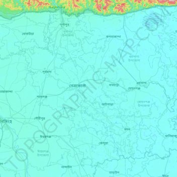
Name: Netrokona District topographic map, elevation, terrain.
Location: Netrokona District, Mymensingh Division, Bangladesh (24.56752 90.46242 25.18111 91.22289)
Average elevation: 17 m
Minimum elevation: -1 m
Maximum elevation: 442 m
Make a donation
Gear up for your next adventure:
As an Amazon Associate, this site earns from qualifying purchases at no extra cost to you.
Other topographic maps
Click on a map to view its topography, its elevation and its terrain.
Brahmaputra River
Bangladesh > Mymensingh Division > Jamalpur Sadar Upazila > Jamalpur
The course of the Brahmaputra River has changed drastically in the past two and a half centuries, moving its river course westwards for a distance of about 80 km (50 mi), leaving its old river course, appropriately named the old Brahmaputra river, behind. In the past, the floodplain of the old river course had…
Average elevation: 18 m
Mymensingh
Bangladesh > Mymensingh Division > Mymensingh
Mymensingh is the 8th administrative divisional headquarter and 12th city corporation of Bangladesh. According to Ministry of Public Administration, Mymensingh is ranked 4th in district status. The density of Mymensingh city is 44,458/km2 (115,150/sq mi) which is the second most densely populated city in…
Average elevation: 14 m
Make a donation
Gear up for your next adventure:
As an Amazon Associate, this site earns from qualifying purchases at no extra cost to you.