
Feni District topographic map
Interactive map
Click on the map to display elevation.
About this map
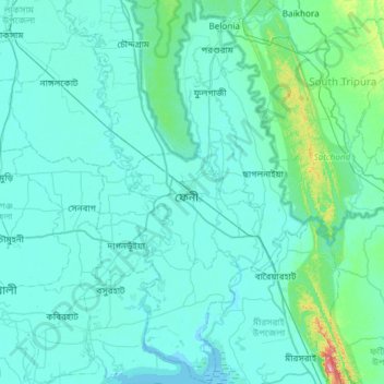
Name: Feni District topographic map, elevation, terrain.
Location: Feni District, Chattogram Division, Bangladesh (22.73813 91.24957 23.28665 91.58487)
Average elevation: 19 m
Minimum elevation: -2 m
Maximum elevation: 263 m
Other topographic maps
Click on a map to view its topography, its elevation and its terrain.
Sajek Valley - সাজেক ভ্যালি / মেঘের উপত্যকায় জীবন
Bangladesh > Chattogram Division > Bagaichhari Upazila > Sajek
Average elevation: 256 m
Rangamati
Bangladesh > Chattogram Division > Rangamati Sadar Upazila
Rangamati (Bengali: রাঙ্গামাটি is the administrative headquarter and town of Rangamati District in the Chittagong Hill Tracts of Bangladesh. The town is located at 22°37'60N 92°12'0E and has an altitude of 14 metres (46 ft). It was the capital of the Chakma kingdom during the British rule…
Average elevation: 68 m
Cox's Bazar
Bangladesh > Chattogram Division > Cox's Bazar District > Cox's Bazar
Cox's Bazar lies on a coastal plain in the southeastern corner of Bangladesh. From above, the plain appears to bulge out into the Bay of Bengal. Along the shore is an extensive area of beach and dunes. Most of the city is built on a floodplain that is lower in elevation than the dunes, making it more…
Average elevation: 13 m