
Whitstable topographic map
Click on the map to display elevation.
About this map
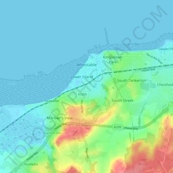
Name: Whitstable topographic map, elevation, terrain.
Location: Whitstable, Kent, England, United Kingdom (51.33643 0.98582 51.36974 1.08098)
Average elevation: 15 m
Minimum elevation: -1 m
Maximum elevation: 74 m
Other topographic maps
Click on a map to view its topography, its elevation and its terrain.
Greatstone on Sea
United Kingdom > England > Kent > Folkestone and Hythe District > New Romney
Average elevation: 2 m
Ightham Common
United Kingdom > England > Kent > Tonbridge and Malling > Ightham
Average elevation: 145 m
Romney, Hythe and Dymchurch Railway
United Kingdom > England > Kent > Folkestone and Hythe > St. Mary in the Marsh
Average elevation: 1 m
Stowting Common
United Kingdom > England > Kent > Folkestone and Hythe > Lymbridge Green > Stowting Common
Average elevation: 148 m
Faversham Creek
United Kingdom > England > Kent > Borough of Swale > Faversham > Oare
Average elevation: 8 m
Faversham Creek
United Kingdom > England > Kent > Borough of Swale > Faversham > Oare
Average elevation: 11 m
Barden Lake
United Kingdom > England > Kent > Tonbridge and Malling > Tonbridge
Average elevation: 33 m
Whitstable and Seasalter Golf Club
United Kingdom > England > Kent > Whitstable > Seasalter
Average elevation: 14 m
Kit's Coty
United Kingdom > England > Kent > Tonbridge and Malling > Bluebell Hill
Average elevation: 102 m
St Margaret's Bay
United Kingdom > England > Kent > Dover > St. Margaret's at Cliffe
Average elevation: 38 m
Hickmans Green
United Kingdom > England > Kent > Borough of Swale > Boughton Street
Average elevation: 63 m
Knatts Valley
United Kingdom > England > Kent > Sevenoaks > East Hill > Knockmill
Average elevation: 170 m