Geolocate

Istead Rise topographic map

Interactive map

Click on the map to display elevation.

About this map

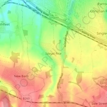
Name: Istead Rise topographic map, elevation, terrain.

Location: Istead Rise, Gravesham, Kent, England, DA13 9JT, United Kingdom (51.38489 0.32983 51.42489 0.36983)

Average elevation: 63 m

Minimum elevation: 13 m

Maximum elevation: 107 m

Other topographic maps

Click on a map to view its topography, its elevation and its terrain.

Northfleet

United Kingdom > England > Kent > Gravesham

Average elevation: 33 m

Gravesend

United Kingdom > England > Kent > Gravesham

Average elevation: 31 m

Luddesdown

United Kingdom > England > Kent > Gravesham

Average elevation: 109 m

Robins Creek

United Kingdom > England > Kent > Gravesham > Northfleet

Average elevation: 10 m

Shorne Wood

United Kingdom > England > Kent > Gravesham > Shorne Ridgeway

Average elevation: 83 m

Vigo

United Kingdom > England > Kent > Gravesham

Average elevation: 160 m

Meopham

United Kingdom > England > Kent > Gravesham > Meopham

Average elevation: 124 m

Shorne

United Kingdom > England > Kent > Gravesham > Higham

Average elevation: 35 m