
Central Java topographic map
Interactive map
Click on the map to display elevation.
Central Java
The Southern Serayu Mountains are part of the South Central Java Basin located in the southern part of the province. This mandala is a geoantiklin that extends from west to east along 100 kilometres and is divided into two parts separated by the Jatilawang valley, namely the western and eastern regions. The western part is formed by Mount Kabanaran (360 m) and can be described as having the same elevation as the Bandung Depression Zone in West Java or as a new structural element in Central Java. This section is separated from the Bogor Zone by the Majenang Depression.
About this map
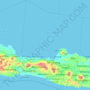
Name: Central Java topographic map, elevation, terrain.
Location: Central Java, Java, Indonesia (-8.44119 108.55585 -4.03879 111.86897)
Average elevation: 83 m
Minimum elevation: -2 m
Maximum elevation: 3,247 m
Other topographic maps
Click on a map to view its topography, its elevation and its terrain.
Bandung
Indonesia > West Java > Bandung
Bandung, the capital of West Java province, located about 180 kilometres (110 mi) southeast of Jakarta, is the third-largest city in Indonesia. Its elevation is 768 metres (2,520 ft) above sea level and is surrounded by up to 2,400 metres (7,900 feet) high Late Tertiary and Quaternary volcanic terrain. The 400…
Average elevation: 879 m
East Java
East Java has a tropical monsoon and savanna climate at lower elevation and subtropical at higher elevation. Compared with the western part of Java Island, East Java in general has less rainfall. Average rainfall is 1,900 mm per year, with a rainy season during the 100 days. The average temperature ranges…
Average elevation: 66 m
PT Galangan Kapal Bontuni Tirtamas
Indonesia > Southeast Sulawesi > Kendari > Kessilampe
Average elevation: 23 m