Geolocate

Bukateja topographic map

Click on the map to display elevation.

About this map

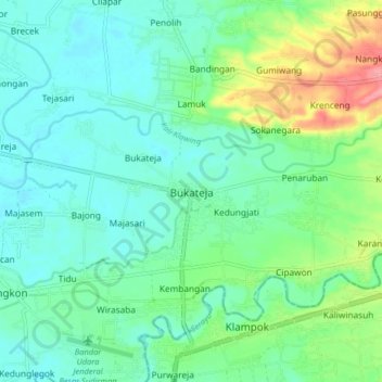
Name: Bukateja topographic map, elevation, terrain.

Location: Bukateja, Purbalingga, Central Java, Java, 53382, Indonesia (-7.46861 109.39357 -7.38861 109.47357)

Average elevation: 51 m

Minimum elevation: 25 m

Maximum elevation: 128 m

Gear up for your next adventure:

🔦Everyday Carry Torches - Reliable backup light for your hiking pack
🧢Hiking Hats & Caps - Protective headwear for sun and rain
📸Travel Camera Tripods - Steady shots for landscape and long-exposure photos
🎒Waterproof Backpacks - Protect your gear from rain on Irish hikes
🥣Outdoor Food & Meals - Dehydrated meals for backpacking

As an Amazon Associate, this site earns from qualifying purchases at no extra cost to you.