
Thank you for supporting this site ❤️
Make a donation
Make a donation
Gear up for your next adventure:
As an Amazon Associate, this site earns from qualifying purchases at no extra cost to you.
Kacinambun topographic map
Click on the map to display elevation.
Thank you for supporting this site ❤️
Make a donation
Make a donation
Gear up for your next adventure:
As an Amazon Associate, this site earns from qualifying purchases at no extra cost to you.
About this map
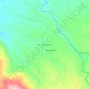
Name: Kacinambun topographic map, elevation, terrain.
Location: Kacinambun, Karo, North Sumatra, Indonesia (3.00861 98.45162 3.04861 98.49162)
Average elevation: 1,245 m
Minimum elevation: 1,156 m
Maximum elevation: 1,436 m
Thank you for supporting this site ❤️
Make a donation
Make a donation
Gear up for your next adventure:
As an Amazon Associate, this site earns from qualifying purchases at no extra cost to you.