
Gilpin County topographic map
Click on the map to display elevation.
About this map
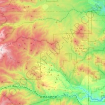
Name: Gilpin County topographic map, elevation, terrain.
Location: Gilpin County, Colorado, United States (39.74581 -105.70085 39.93640 -105.39661)
Average elevation: 2,748 m
Minimum elevation: 2,057 m
Maximum elevation: 3,702 m
Other topographic maps
Click on a map to view its topography, its elevation and its terrain.
Steamboat Springs
United States > Colorado > Routt County > Steamboat Springs
Average elevation: 2,228 m