
Fort Collins topographic map
Click on the map to display elevation.
About this map
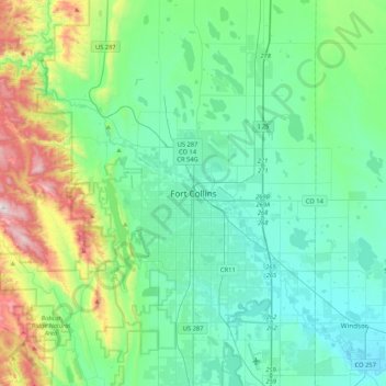
Name: Fort Collins topographic map, elevation, terrain.
Average elevation: 1,644 m
Minimum elevation: 1,443 m
Maximum elevation: 2,401 m
Other topographic maps
Click on a map to view its topography, its elevation and its terrain.
Rocky Mountain National Park
United States > Colorado > Larimer County
Rocky Mountain National Park is one of the highest national parks in the nation, with elevations from 7,860 to 14,259 feet (2,396 to 4,346 m), the highest point of which is Longs Peak. Trail Ridge Road is the highest paved through-road in the country, with a peak elevation of 12,183 feet (3,713 m). Sixty…
Average elevation: 3,073 m
Estes Park
United States > Colorado > Larimer County
Estes Park sits at an elevation of 7,522 feet (2,293 m) on the front range of the Rocky Mountains at the eastern entrance of the Rocky Mountain National Park. Its location is 40°22′22″N 105°31′09″W / 40.372856°N 105.519136°W / 40.372856; -105.519136. Its north, south and east extremities…
Average elevation: 2,421 m