
Dolores County topographic map
Interactive map
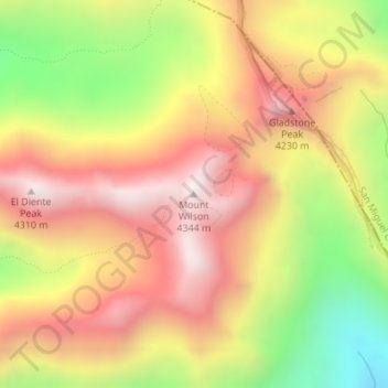
Click on the map to display elevation.
About this map
Name: Dolores County topographic map, elevation, terrain.
Location: Dolores County, Colorado, United States, Mount Wilson (37.83916 -107.99168 37.83926 -107.99158)
Average elevation: 3,892 m
Minimum elevation: 3,378 m
Maximum elevation: 4,291 m
Other topographic maps
Click on a map to view its topography, its elevation and its terrain.
Douglas County
Douglas County, Colorado, United States
Average elevation: 2,104 m
Evans
United States > Colorado > Weld County
Evans, Weld County, Colorado, United States
Average elevation: 1,429 m
Castle Rock
United States > Colorado > Douglas County
Castle Rock, Douglas County, Colorado, United States
Average elevation: 1,952 m
Creede
United States > Colorado > Mineral County
Creede, Mineral County, Colorado, United States
Average elevation: 2,891 m
Estes Park
United States > Colorado > Larimer County
Estes Park, Larimer County, Colorado, 80517, United States
Average elevation: 2,421 m
Manitou Springs
United States > Colorado > El Paso County
Manitou Springs, El Paso County, Colorado, 80829, United States
Average elevation: 2,144 m
Steamboat Springs
United States > Colorado > Routt County > Steamboat Springs
Steamboat Springs, Routt County, Colorado, United States
Average elevation: 2,228 m
Rustic
United States > Colorado > Rustic
Rustic, Larimer County, Colorado, United States
Average elevation: 2,390 m
Colorado Springs
United States > Colorado > Colorado Springs
Colorado Springs, El Paso County, Colorado, United States
Average elevation: 2,252 m
Denver
United States > Colorado > Denver
Denver, Denver County, Colorado, United States
Average elevation: 1,684 m
San Miguel County
San Miguel County, Colorado, United States
Average elevation: 2,390 m
San Juan County
San Juan County, Colorado, 81433, United States
Average elevation: 3,478 m
The Flat Tops
The Flat Tops, Mesa County, Colorado, United States
Average elevation: 3,207 m
Boulder County
United States > Colorado > Boulder County
Boulder County, Colorado, United States
Average elevation: 2,308 m
Montezuma County
Montezuma County, Colorado, United States
Average elevation: 2,025 m
Custer County
Custer County, Colorado, United States
Average elevation: 2,616 m