Geolocate

Creede topographic map

Click on the map to display elevation.

About this map

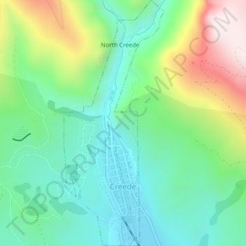
Name: Creede topographic map, elevation, terrain.

Location: Creede, Mineral County, Colorado, United States (37.84167 -106.93432 37.86914 -106.91963)

Average elevation: 2,891 m

Minimum elevation: 2,669 m

Maximum elevation: 3,371 m

Gear up for your next adventure:

🧤Thermal Outdoor Gloves - Windproof and waterproof gloves for winter hiking
🪓Camping Hand Axes - For processing wood during forest camping
🧢Hiking Hats & Caps - Protective headwear for sun and rain
🥾Hiking Boots - Top hiking boots for Irish trails and rugged terrain
🗺️Irish Road Atlases - Comprehensive physical maps for road trips and navigation

As an Amazon Associate, this site earns from qualifying purchases at no extra cost to you.