
Make a donation
Gear up for your next adventure:
As an Amazon Associate, this site earns from qualifying purchases at no extra cost to you.
Douglas County topographic map
Click on the map to display elevation.
Make a donation
Gear up for your next adventure:
As an Amazon Associate, this site earns from qualifying purchases at no extra cost to you.
About this map
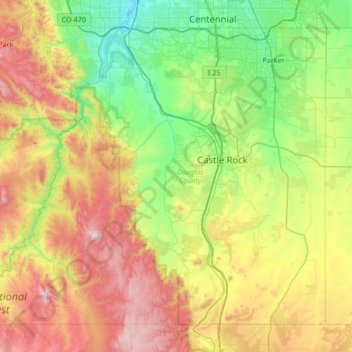
Name: Douglas County topographic map, elevation, terrain.
Location: Douglas County, Colorado, United States (39.12949 -105.32945 39.56615 -104.66061)
Average elevation: 2,104 m
Minimum elevation: 1,626 m
Maximum elevation: 2,975 m
Make a donation
Gear up for your next adventure:
As an Amazon Associate, this site earns from qualifying purchases at no extra cost to you.
Other topographic maps
Click on a map to view its topography, its elevation and its terrain.
Make a donation
Gear up for your next adventure:
As an Amazon Associate, this site earns from qualifying purchases at no extra cost to you.
Steamboat Springs
United States > Colorado > Routt County > Steamboat Springs
Average elevation: 2,228 m