Geolocate

Fairview topographic map

Click on the map to display elevation.

About this map

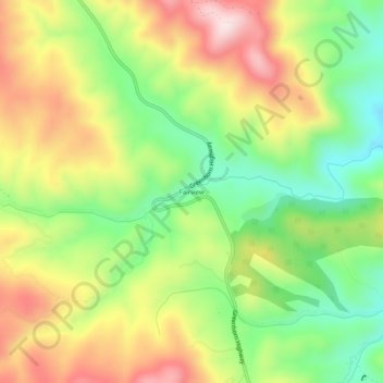
Name: Fairview topographic map, elevation, terrain.

Location: Fairview, Custer County, Colorado, United States (38.04778 -105.11916 38.08778 -105.07916)

Average elevation: 2,765 m

Minimum elevation: 2,565 m

Maximum elevation: 3,001 m

Gear up for your next adventure:

🎒Hiking Backpacks - Durable backpacks for day hikes and multi‑day treks
🧉Camping Coffee Gear - Enjoy coffee outdoors
🚰Hydration Packs - Hands‑free water storage for hikers
🔋Lithium Batteries - Best performance for digital devices in cold weather
🎒Waterproof Backpacks - Protect your gear from rain on Irish hikes

As an Amazon Associate, this site earns from qualifying purchases at no extra cost to you.