
Eagle County topographic map
Interactive map
Click on the map to display elevation.
About this map
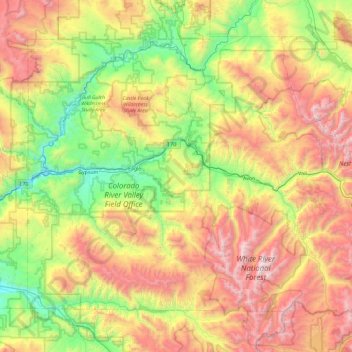
Name: Eagle County topographic map, elevation, terrain.
Location: Eagle County, Colorado, United States (39.34949 -107.11374 39.92530 -106.17557)
Average elevation: 2,769 m
Minimum elevation: 1,871 m
Maximum elevation: 4,196 m
The highest elevation in the county is the Mount of the Holy Cross which rises to 14,011 feet (4,271 m) above sea level. The lowest elevation is on the Colorado River at 6,128 feet (1,868 m).
Other topographic maps
Click on a map to view its topography, its elevation and its terrain.
Douglas County
Douglas County, Colorado, United States
Average elevation: 2,104 m
Evans
United States > Colorado > Weld County
Evans, Weld County, Colorado, United States
Average elevation: 1,429 m
Castle Rock
United States > Colorado > Douglas County
Castle Rock, Douglas County, Colorado, United States
Average elevation: 1,952 m
Dolores County
Dolores County, Colorado, United States, Mount Wilson
Average elevation: 3,892 m
Creede
United States > Colorado > Mineral County
Creede, Mineral County, Colorado, United States
Average elevation: 2,891 m
Estes Park
United States > Colorado > Larimer County
Estes Park, Larimer County, Colorado, 80517, United States
Average elevation: 2,421 m
Manitou Springs
United States > Colorado > El Paso County
Manitou Springs, El Paso County, Colorado, 80829, United States
Average elevation: 2,144 m
Steamboat Springs
United States > Colorado > Routt County > Steamboat Springs
Steamboat Springs, Routt County, Colorado, United States
Average elevation: 2,228 m
Rustic
United States > Colorado > Rustic
Rustic, Larimer County, Colorado, United States
Average elevation: 2,390 m
Colorado Springs
United States > Colorado > Colorado Springs
Colorado Springs, El Paso County, Colorado, United States
Average elevation: 2,252 m
Denver
United States > Colorado > Denver
Denver, Denver County, Colorado, United States
Average elevation: 1,684 m
San Miguel County
San Miguel County, Colorado, United States
Average elevation: 2,390 m
San Juan County
San Juan County, Colorado, 81433, United States
Average elevation: 3,478 m
The Flat Tops
The Flat Tops, Mesa County, Colorado, United States
Average elevation: 3,207 m
Boulder County
United States > Colorado > Boulder County
Boulder County, Colorado, United States
Average elevation: 2,308 m
Montezuma County
Montezuma County, Colorado, United States
Average elevation: 2,025 m
Custer County
Custer County, Colorado, United States
Average elevation: 2,616 m