
East Kalimantan topographic map
Interactive map
Click on the map to display elevation.
About this map
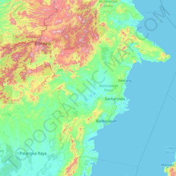
Name: East Kalimantan topographic map, elevation, terrain.
Location: East Kalimantan, Indonesia (-2.65372 113.83434 2.56902 119.66809)
Average elevation: 218 m
Minimum elevation: -4 m
Maximum elevation: 2,103 m
Other topographic maps
Click on a map to view its topography, its elevation and its terrain.
Bandung
Indonesia > West Java > Bandung
Bandung, the capital of West Java province, located about 180 kilometres (110 mi) southeast of Jakarta, is the third-largest city in Indonesia. Its elevation is 768 metres (2,520 ft) above sea level and is surrounded by up to 2,400 metres (7,900 feet) high Late Tertiary and Quaternary volcanic terrain. The 400…
Average elevation: 879 m
East Java
East Java has a tropical monsoon and savanna climate at lower elevation and subtropical at higher elevation. Compared with the western part of Java Island, East Java in general has less rainfall. Average rainfall is 1,900 mm per year, with a rainy season during the 100 days. The average temperature ranges…
Average elevation: 66 m
PT Galangan Kapal Bontuni Tirtamas
Indonesia > Southeast Sulawesi > Kendari > Kessilampe
Average elevation: 23 m