
Make a donation
Gear up for your next adventure:
As an Amazon Associate, this site earns from qualifying purchases at no extra cost to you.
Africa topographic map
Click on the map to display elevation.
Make a donation
Gear up for your next adventure:
As an Amazon Associate, this site earns from qualifying purchases at no extra cost to you.
Africa
Africa's topography is a complex tapestry of plateaus, mountains, valleys, and deserts. The continent is dominated by vast plateaus, with elevations averaging around 1,000 meters (3,281 feet), especially prominent in the south and east. The Ethiopian Highlands, often referred to as the "Roof of Africa," rise to formidable heights, with peaks such as Ras Dejen reaching 4,550 meters (14,928 feet). The Great Rift Valley, a significant geological feature, stretches from the Red Sea down to Mozambique, creating deep depressions hosting some of Africa's largest lakes, including Lake Tanganyika and Lake Malawi, and marked by volcanic mountains such as Mount Kilimanjaro, Africa's highest point at 5,895 metres (19,341 ft) and Mount Kenya. In the northwest, the Atlas Mountains extend through Morocco, Algeria, and Tunisia, with Mount Toubkal standing as the range's highest point at 4,167 meters (13,671 feet). Contrasting these elevations, the Sahara Desert sprawls across North Africa, characterized by expansive sand dunes and rocky plateaus. The southern part of Africa includes the Kalahari Desert and the Drakensberg Mountains, which rise steeply from the plains. This diverse terrain influences the continent's climate, biodiversity, and human settlements.
Make a donation
Gear up for your next adventure:
As an Amazon Associate, this site earns from qualifying purchases at no extra cost to you.
About this map
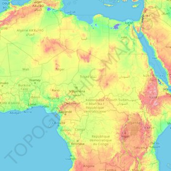
Name: Africa topographic map, elevation, terrain.
Location: Africa (-13.49757 -7.24219 36.50243 42.75781)
Average elevation: 462 m
Minimum elevation: -415 m
Maximum elevation: 4,436 m
Make a donation
Gear up for your next adventure:
As an Amazon Associate, this site earns from qualifying purchases at no extra cost to you.
Other topographic maps
Click on a map to view its topography, its elevation and its terrain.
Ireland
Ireland's topography is characterized by a central limestone plain, averaging about 75 meters (246 feet) above sea level, interspersed with numerous lakes, bogs, and low ridges. This plain is encircled by coastal mountains of varying geological compositions. In the southwest, the MacGillycuddy's Reeks,…
Average elevation: 44 m
Virginia
Forests cover 62% of Virginia as of 2021, of which 80% is considered hardwood forest, meaning that trees in Virginia are primarily deciduous and broad-leaved. The other 20% is pine, with loblolly and shortleaf pine dominating much of central and eastern Virginia. In the western and mountainous parts of the…
Average elevation: 248 m
Bangladesh
Bangladesh is predominantly rich fertile flat land. Most of it is less than 12 m (39 ft) above sea level, and it is estimated that about 10% of its land would be flooded if the sea level were to rise by 1 m (3.3 ft). 17% of the country is covered by forests and 12% is covered by hill systems. The country's…
Average elevation: 161 m
Make a donation
Gear up for your next adventure:
As an Amazon Associate, this site earns from qualifying purchases at no extra cost to you.
Croatia
The territory covers 56,594 square kilometres (21,851 square miles), consisting of 56,414 square kilometres (21,782 square miles) of land and 128 square kilometres (49 square miles) of water. It is the world's 127th largest country. Elevation ranges from the mountains of the Dinaric Alps with the highest point…
Average elevation: 323 m
Czechia
Temperatures vary depending on the elevation. In general, at higher altitudes, the temperatures decrease and precipitation increases. The wettest area in the Czech Republic is found around Bílý Potok in Jizera Mountains and the driest region is the Louny District to the northwest of Prague. Another factor is…
Average elevation: 369 m
Make a donation
Gear up for your next adventure:
As an Amazon Associate, this site earns from qualifying purchases at no extra cost to you.
Madagascar
Along the length of the eastern coast runs a narrow and steep escarpment containing much of the island's remaining tropical lowland forest. To the west of this ridge lies a plateau in the center of the island ranging in altitude from 750 to 1,500 m (2,460 to 4,920 ft) above sea level. These central highlands,…
Average elevation: 139 m
El Salvador
El Salvador has a tropical climate with pronounced wet and dry seasons. Temperatures vary primarily with elevation and show little seasonal change. The Pacific lowlands are uniformly hot; the central plateau and mountain areas are more moderate. The rainy season extends from May to October; this time of year…
Average elevation: 484 m
Make a donation
Gear up for your next adventure:
As an Amazon Associate, this site earns from qualifying purchases at no extra cost to you.
Make a donation
Gear up for your next adventure:
As an Amazon Associate, this site earns from qualifying purchases at no extra cost to you.
County Kilkenny
The River Nore flows through the county and the River Suir forms the border with County Waterford. Brandon Hill is the highest point with an elevation of 515 m (1,690 ft). Most of the county has a hilly surface of moderate elevation with uplands in the north-east, the north-west and the South of the county;…
Average elevation: 120 m
County Dublin
Dublin is a topographically varied region. The city centre is generally very low-lying, and many areas of coastal Dublin are at or near sea-level. In the south of the county, the topography rises steeply from sea-level at the coast to over 500 metres (1,600 ft) in just a few kilometres. This natural barrier…
Average elevation: 71 m
Make a donation
Gear up for your next adventure:
As an Amazon Associate, this site earns from qualifying purchases at no extra cost to you.
County Donegal
The majority of Donegal has a temperate oceanic climate (Köppen climate classification: Cfb), with upland areas in the Derryveagh and Blue Stack ranges classified as oceanic subpolar (Köppen climate classification: Cfc). The county's climate is heavily influenced by the North Atlantic Current. Due to the…
Average elevation: 73 m
Make a donation
Gear up for your next adventure:
As an Amazon Associate, this site earns from qualifying purchases at no extra cost to you.
Make a donation
Gear up for your next adventure:
As an Amazon Associate, this site earns from qualifying purchases at no extra cost to you.
County Carlow
The soils of the county are mostly derived from glacial till, rather than solid bedrock geology. These typically consist of a mix of clay, sand and gravel. Occasionally glacial melt-water would form a long ridge of sand and gravel known as an esker. One such example is preserved within the county and is a…
Average elevation: 126 m
Make a donation
Gear up for your next adventure:
As an Amazon Associate, this site earns from qualifying purchases at no extra cost to you.
Brosna
Works, to the cost of IR £750,000, were undertaken on the river in the late 1940s and early 1950s to improve drainage in the river’s catchment area. As part of the Arterial Drainage Scheme, designed to tackle poor drainage caused by Ireland’s relatively low-lying topography, the river was deepened and…
Average elevation: 75 m
Make a donation
Gear up for your next adventure:
As an Amazon Associate, this site earns from qualifying purchases at no extra cost to you.
Make a donation
Gear up for your next adventure:
As an Amazon Associate, this site earns from qualifying purchases at no extra cost to you.
Make a donation
Gear up for your next adventure:
As an Amazon Associate, this site earns from qualifying purchases at no extra cost to you.
Make a donation
Gear up for your next adventure:
As an Amazon Associate, this site earns from qualifying purchases at no extra cost to you.
Make a donation
Gear up for your next adventure:
As an Amazon Associate, this site earns from qualifying purchases at no extra cost to you.
Make a donation
Gear up for your next adventure:
As an Amazon Associate, this site earns from qualifying purchases at no extra cost to you.
Make a donation
Gear up for your next adventure:
As an Amazon Associate, this site earns from qualifying purchases at no extra cost to you.
Make a donation
Gear up for your next adventure:
As an Amazon Associate, this site earns from qualifying purchases at no extra cost to you.
Make a donation
Gear up for your next adventure:
As an Amazon Associate, this site earns from qualifying purchases at no extra cost to you.
Make a donation
Gear up for your next adventure:
As an Amazon Associate, this site earns from qualifying purchases at no extra cost to you.
Make a donation
Gear up for your next adventure:
As an Amazon Associate, this site earns from qualifying purchases at no extra cost to you.
Make a donation
Gear up for your next adventure:
As an Amazon Associate, this site earns from qualifying purchases at no extra cost to you.
Make a donation
Gear up for your next adventure:
As an Amazon Associate, this site earns from qualifying purchases at no extra cost to you.
Make a donation
Gear up for your next adventure:
As an Amazon Associate, this site earns from qualifying purchases at no extra cost to you.
Make a donation
Gear up for your next adventure:
As an Amazon Associate, this site earns from qualifying purchases at no extra cost to you.
Make a donation
Gear up for your next adventure:
As an Amazon Associate, this site earns from qualifying purchases at no extra cost to you.
Make a donation
Gear up for your next adventure:
As an Amazon Associate, this site earns from qualifying purchases at no extra cost to you.