
旭水公園 topographic map
Interactive map
Click on the map to display elevation.
About this map
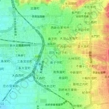
Name: 旭水公園 topographic map, elevation, terrain.
Location: 旭水公園, 下三条町, 奈良市, 奈良縣, 日本 (34.68206 135.82376 34.68214 135.82390)
Average elevation: 81 m
Minimum elevation: 56 m
Maximum elevation: 116 m
Other topographic maps
Click on a map to view its topography, its elevation and its terrain.