
Make a donation
Gear up for your next adventure:
As an Amazon Associate, this site earns from qualifying purchases at no extra cost to you.
Morogoro Region topographic map
Click on the map to display elevation.
Make a donation
Gear up for your next adventure:
As an Amazon Associate, this site earns from qualifying purchases at no extra cost to you.
Morogoro Region
The Morogoro region has a total size of 73,039 square kilometers, which is split between land (70,967 square kilometers, or 97.2 percent of the total area), and water (2,073 km2 or 2.8 percent). As of 2012, Ulanga District is the largest district,Malinyi DC comes in second with 17.0 percent of the region's total land area, followed by Morogoro DC with 16.1 percent. Kilosa District comes in first with 18.6 percent. Morogoro Municipal was the district with the smallest land size (531 km2 or 10.7%), followed by Gairo DC with (1,851 km2 or 2.5 percent). Different scenarios exist in Kilosa DC, Malinyi DC, Ifakara TC, Ulanga DC, Morogoro MC, and Gairo DC, with all of their respective territories being completely covered by land. While Mvomero DC (1,882 km2) has the most water area in the area. At Mlimba DC, there is the smallest water area (70 km2). According to topographical and ecological zones, the region's soils differ.
Make a donation
Gear up for your next adventure:
As an Amazon Associate, this site earns from qualifying purchases at no extra cost to you.
About this map
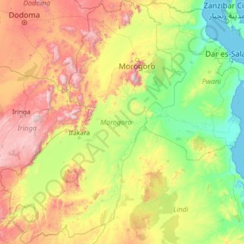
Name: Morogoro Region topographic map, elevation, terrain.
Location: Morogoro Region, Coastal Zone, Tanzania (-9.92346 35.32406 -5.80227 38.51660)
Average elevation: 539 m
Minimum elevation: 0 m
Maximum elevation: 2,560 m
Make a donation
Gear up for your next adventure:
As an Amazon Associate, this site earns from qualifying purchases at no extra cost to you.
Other topographic maps
Click on a map to view its topography, its elevation and its terrain.
Uhuru Peak
Kilimanjaro is the fourth most topographically prominent peak on Earth. It is part of Kilimanjaro National Park and is a major hiking and climbing destination. Because of its shrinking glaciers and ice fields, which are projected to disappear between 2025 and 2035, it has been the subject of many scientific…
Average elevation: 5,494 m
Arusha
Despite its proximity to the equator, Arusha's elevation of 1,400 metres (4,600 ft) on the southern slopes of Mount Meru keeps temperatures relatively low and alleviates humidity. Cool dry air is prevalent for much of the year. The temperature typically ranges between 10 and 30 °C (50 and 86 °F) with an…
Average elevation: 1,572 m
Make a donation
Gear up for your next adventure:
As an Amazon Associate, this site earns from qualifying purchases at no extra cost to you.
Make a donation
Gear up for your next adventure:
As an Amazon Associate, this site earns from qualifying purchases at no extra cost to you.