
Make a donation
Gear up for your next adventure:
As an Amazon Associate, this site earns from qualifying purchases at no extra cost to you.
Matongo topographic map
Click on the map to display elevation.
Make a donation
Gear up for your next adventure:
As an Amazon Associate, this site earns from qualifying purchases at no extra cost to you.
About this map
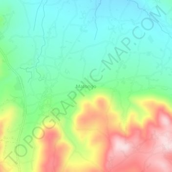
Name: Matongo topographic map, elevation, terrain.
Location: Matongo, Butiama, Lake Zone, Tanzania (-1.73473 34.05268 -1.69473 34.09268)
Average elevation: 1,367 m
Minimum elevation: 1,248 m
Maximum elevation: 1,577 m
Make a donation
Gear up for your next adventure:
As an Amazon Associate, this site earns from qualifying purchases at no extra cost to you.
Other topographic maps
Click on a map to view its topography, its elevation and its terrain.
Mbeya Region
The Great Rift Valley created the majority of the places in the area, with the lowland elevation occupying the Western Rift Zone, which includes the Lake Rukwa and Lake Nyasa regions, and the Eastern Rift Zone, which includes the Usangu Plains and other sections of the Ruaha Trough. The heights range from 475…
Average elevation: 1,314 m
Kigoma Region
Kigoma Region is on a plateau that slopes from the northeast at about 1,750 metres (5,740 ft) down to 800 metres (2,600 ft) at the shore of lake Tanganyika. The topography in the north and east is gently rolling hills that gradually become steeper as they get closer to the Albertine Rift margin. The most…
Average elevation: 1,215 m
Make a donation
Gear up for your next adventure:
As an Amazon Associate, this site earns from qualifying purchases at no extra cost to you.
Make a donation
Gear up for your next adventure:
As an Amazon Associate, this site earns from qualifying purchases at no extra cost to you.
Morogoro Region
The Morogoro region has a total size of 73,039 square kilometers, which is split between land (70,967 square kilometers, or 97.2 percent of the total area), and water (2,073 km2 or 2.8 percent). As of 2012, Ulanga District is the largest district,Malinyi DC comes in second with 17.0 percent of the region's…
Average elevation: 539 m