
Split-Dalmatia County topographic map
Interactive map
Click on the map to display elevation.
About this map
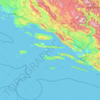
Name: Split-Dalmatia County topographic map, elevation, terrain.
Location: Split-Dalmatia County, Croatia (42.17660 15.18586 43.97399 17.45085)
Average elevation: 255 m
Minimum elevation: -5 m
Maximum elevation: 2,177 m
Other topographic maps
Click on a map to view its topography, its elevation and its terrain.
Otočac
Croatia > Lika-Senj County > Otočac
Otočac is located in the western part of Gacko Polje, the karst field of centrally located Gacka river, located between Velebit and Mala Kapela, at an elevation of 459m. The town lies to the southeast of Senj, northwest of Gospić and west of Plitvice.
Average elevation: 511 m
Sisak
Sisak (Croatian: ; Hungarian: Sziszek ; also known by other alternative names) is a city in central Croatia, spanning the confluence of the Kupa, Sava and Odra rivers, 57 km (35 mi) southeast of the Croatian capital Zagreb, and is usually considered to be where the Posavina (Sava basin) begins, with an…
Average elevation: 98 m
Vinkovci
Croatia > Vukovar-Srijem County > Vinkovci
Vinkovci is located in the eastern part of the Slavonia region, 19 km (12 mi) southwest of Vukovar, 24 km (15 mi) north of Županja and 43 km (27 mi) south of Osijek. The city lies in a flatland on the Bosut river, at an elevation of approx. 90 metres (300 ft), and has a mild continental climate. Vinkovci is…
Average elevation: 89 m
Gorica Svetojanska
Croatia > Zagreb County > Grad Jastrebarsko > Gorica Svetojanska
Average elevation: 304 m