
Make a donation
Gear up for your next adventure:
As an Amazon Associate, this site earns from qualifying purchases at no extra cost to you.
Otočac topographic map
Click on the map to display elevation.
Make a donation
Gear up for your next adventure:
As an Amazon Associate, this site earns from qualifying purchases at no extra cost to you.
Otočac
Otočac is located in the western part of Gacko Polje, the karst field of centrally located Gacka river, located between Velebit and Mala Kapela, at an elevation of 459m. The town lies to the southeast of Senj, northwest of Gospić and west of Plitvice.
Make a donation
Gear up for your next adventure:
As an Amazon Associate, this site earns from qualifying purchases at no extra cost to you.
About this map
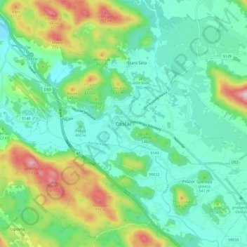
Name: Otočac topographic map, elevation, terrain.
Location: Otočac, Grad Otočac, Lika-Senj County, 53220, Croatia (44.82880 15.19587 44.90880 15.27587)
Average elevation: 511 m
Minimum elevation: 418 m
Maximum elevation: 758 m
Make a donation
Gear up for your next adventure:
As an Amazon Associate, this site earns from qualifying purchases at no extra cost to you.