
Thank you for supporting this site ❤️
Make a donation
Make a donation
Gear up for your next adventure:
As an Amazon Associate, this site earns from qualifying purchases at no extra cost to you.
Gnječi topographic map
Click on the map to display elevation.
Thank you for supporting this site ❤️
Make a donation
Make a donation
Gear up for your next adventure:
As an Amazon Associate, this site earns from qualifying purchases at no extra cost to you.
About this map
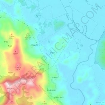
Name: Gnječi topographic map, elevation, terrain.
Location: Gnječi, Grad Ploče, Dubrovnik-Neretva County, 20345, Croatia (43.09693 17.42387 43.13693 17.46387)
Average elevation: 110 m
Minimum elevation: 11 m
Maximum elevation: 446 m
Thank you for supporting this site ❤️
Make a donation
Make a donation
Gear up for your next adventure:
As an Amazon Associate, this site earns from qualifying purchases at no extra cost to you.