
Make a donation
Gear up for your next adventure:
As an Amazon Associate, this site earns from qualifying purchases at no extra cost to you.
Maslenica topographic map
Click on the map to display elevation.
Make a donation
Gear up for your next adventure:
As an Amazon Associate, this site earns from qualifying purchases at no extra cost to you.
About this map
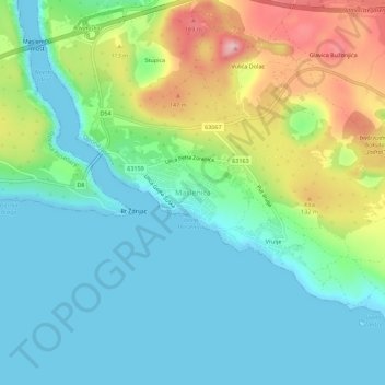
Name: Maslenica topographic map, elevation, terrain.
Location: Maslenica, Općina Jasenice, Zadar County, 23243, Croatia (44.20144 15.52514 44.24144 15.56514)
Average elevation: 55 m
Minimum elevation: -1 m
Maximum elevation: 190 m
Make a donation
Gear up for your next adventure:
As an Amazon Associate, this site earns from qualifying purchases at no extra cost to you.
Other topographic maps
Click on a map to view its topography, its elevation and its terrain.
Dugi Otok
Dugi Otok (pronounced [dûɡiː ǒtok]; Croatian for "long Island", Italian: Isola Lunga) is part of Croatia and the seventh largest island in the Adriatic Sea. It is located off the Dalmatian coast, west of Zadar. It is the largest and westernmost of the Zadarian Islands, and derives its name from its…
Average elevation: 11 m