Geolocate

Kuala Kubu Bharu topographic map

Interactive map

Click on the map to display elevation.

About this map

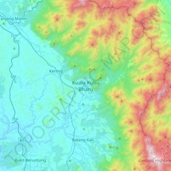
Name: Kuala Kubu Bharu topographic map, elevation, terrain.

Location: Kuala Kubu Bharu, Hulu Selangor, Selangor, Malaysia (3.40406 101.49942 3.72406 101.81942)

Average elevation: 430 m

Minimum elevation: 11 m

Maximum elevation: 1,751 m

Other topographic maps

Click on a map to view its topography, its elevation and its terrain.

Hulu Selangor

Malaysia > Selangor

Average elevation: 345 m

Shah Alam

Malaysia > Selangor

Located in Klang Valley, Shah Alam topography is mostly flat, except in the northern part of the city where it features a prominent rolling hill.

Average elevation: 28 m

Langat River (bypass)

Malaysia > Selangor

Average elevation: 4 m

Kajang Municipal Council

Malaysia > Selangor

Average elevation: 198 m

Section 19

Malaysia > Selangor > SA > Section 19

Average elevation: 10 m

Kuala Selangor

Malaysia > Selangor

Average elevation: 18 m

Subang Jaya

Malaysia > Selangor > Subang Jaya

Average elevation: 27 m

Petaling Jaya

Malaysia > Selangor

Average elevation: 56 m

Kuala Langat

Malaysia > Selangor

Average elevation: 6 m