Geolocate

Shah Alam topographic map

Interactive map

Click on the map to display elevation.

Shah Alam

Located in Klang Valley, Shah Alam topography is mostly flat, except in the northern part of the city where it features a prominent rolling hill.

Wikipedia (CC-BY-SA 3.0)

About this map

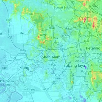
Name: Shah Alam topographic map, elevation, terrain.

Location: Shah Alam, Petaling, Selangor, Malaysia (2.94963 101.42773 3.22995 101.59229)

Average elevation: 28 m

Minimum elevation: -42 m

Maximum elevation: 323 m

Other topographic maps

Click on a map to view its topography, its elevation and its terrain.

Kuala Kubu Bharu

Malaysia > Selangor

Average elevation: 430 m

Serendah

Malaysia > Selangor

Average elevation: 113 m

Langat River (bypass)

Malaysia > Selangor

Average elevation: 4 m

Dengkil

Malaysia > Selangor

Average elevation: 18 m

Sungai Buloh

Malaysia > Selangor

Average elevation: 51 m

Kota Raja

Malaysia > Selangor > SA > Kota Raja

Average elevation: 10 m

Section 19

Malaysia > Selangor > SA > Section 19

Average elevation: 10 m

Ampang Jaya

Malaysia > Selangor > Ampang Jaya

Average elevation: 159 m

Kampung Damai

Malaysia > Selangor > Kuang > Kampung Damai

Average elevation: 43 m