Geolocate

Kajang Municipal Council topographic map

Interactive map

Click on the map to display elevation.

About this map

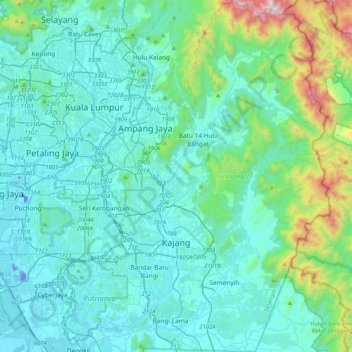
Name: Kajang Municipal Council topographic map, elevation, terrain.

Location: Kajang Municipal Council, Hulu Langat, Selangor, Malaysia (2.86610 101.72088 3.27580 101.96981)

Average elevation: 198 m

Minimum elevation: -27 m

Maximum elevation: 1,435 m

Other topographic maps

Click on a map to view its topography, its elevation and its terrain.

Kuala Kubu Bharu

Malaysia > Selangor

Average elevation: 430 m

Serendah

Malaysia > Selangor

Average elevation: 113 m

Dengkil

Malaysia > Selangor

Average elevation: 18 m

Langat River (bypass)

Malaysia > Selangor

Average elevation: 4 m

Sungai Buloh

Malaysia > Selangor

Average elevation: 51 m

Section 19

Malaysia > Selangor > SA > Section 19

Average elevation: 10 m

Ampang Jaya

Malaysia > Selangor > Ampang Jaya

Average elevation: 159 m

Kampung Damai

Malaysia > Selangor > Kuang > Kampung Damai

Average elevation: 43 m