
Westland District topographic map
Interactive map
Click on the map to display elevation.
About this map
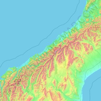
Name: Westland District topographic map, elevation, terrain.
Location: Westland District, West Coast, New Zealand (-44.49907 168.05287 -42.56006 171.88439)
Average elevation: 437 m
Minimum elevation: -1 m
Maximum elevation: 3,457 m
Other topographic maps
Click on a map to view its topography, its elevation and its terrain.
Aramoana
New Zealand > Otago > Dunedin City
Aramoana, Dunedin City, Otago, New Zealand
Average elevation: 26 m
Mount Oval
New Zealand > Canterbury > Hurunui District
Mount Oval, Hurunui District, Canterbury, New Zealand
Average elevation: 506 m
Oyster Island
New Zealand > Nelson > Nelson
Oyster Island, Monaco, Nelson, New Zealand
Average elevation: 0 m
Cone
New Zealand > Manawatū-Whanganui > Tararua District
Cone, Tararua District, Manawatū-Whanganui, New Zealand
Average elevation: 338 m
Omaha Beach
New Zealand > Auckland > Rodney > Omaha
Omaha Beach, Omaha, Rodney, Auckland, New Zealand
Average elevation: 3 m
Rangitīkei District
New Zealand > Manawatū-Whanganui
Rangitīkei District, Manawatū-Whanganui, New Zealand
Average elevation: 538 m
Timaru
New Zealand > Canterbury > Timaru District
Timaru, Timaru District, Canterbury, 7910, New Zealand
Average elevation: 16 m
Mt Baldy
New Zealand > West Coast > Buller District
Mt Baldy, Buller District, West Coast, New Zealand
Average elevation: 1,059 m
Glinks Gully
New Zealand > Northland > Kaipara District
Glinks Gully, Kaipara District, Northland, New Zealand
Average elevation: 43 m
Runciman
New Zealand > Auckland > Franklin > Runciman
Runciman, Franklin, Auckland, 2578, New Zealand
Average elevation: 20 m
Greymouth
New Zealand > West Coast > Grey District > Greymouth
Greymouth, Grey District, West Coast, 7801, New Zealand
Average elevation: 40 m
Chatham Islands
Chatham Islands, Kaiwhata Road, Kaingaroa, Chatham Islands, 8942, New Zealand
Average elevation: 7 m
Hibiscus Coast
New Zealand > Auckland > Hibiscus Coast
Hibiscus Coast, Hibiscus and Bays, Auckland, 0932, New Zealand
Average elevation: 40 m
Dunedin
New Zealand > Otago > Dunedin City
Dunedin, Dunedin City, Otago, 9016, New Zealand
Average elevation: 110 m
Auckland
Auckland, Waitematā, Auckland, 1010, New Zealand
Average elevation: 32 m
South Island
South Island, Ashburton District, Canterbury, New Zealand
Average elevation: 201 m
Motuarohia Island (Roberton Island)
New Zealand > Bay of Islands-Whangaroa Community
Motuarohia Island (Roberton Island), Bay of Islands-Whangaroa Community, Far North District, Northland, New Zealand
Average elevation: 1 m
Little Barrier Island
New Zealand > Auckland > Aotea Great Barrier
Little Barrier Island, Aotea Great Barrier, Auckland, New Zealand
Average elevation: 145 m
White Island
White Island, Bay of Plenty, New Zealand
Average elevation: 38 m
Sandymount
Sandymount, Dunedin, Dunedin City, Otago, New Zealand
Average elevation: 75 m
Mount Wilson
Mount Wilson, Selwyn District, Canterbury, New Zealand
Average elevation: 1,569 m
Christchurch
New Zealand > Canterbury > Christchurch
Christchurch, Christchurch City, Canterbury, New Zealand
Average elevation: 41 m
Dennistoun Glacier
Dennistoun Glacier, Mackenzie District, Canterbury, New Zealand
Average elevation: 2,026 m
Mount Ruapehu
Mount Ruapehu, Ruapehu District, Manawatu-Wanganui, New Zealand
Average elevation: 2,439 m
Aida Glacier
Aida Glacier, Mackenzie District, Canterbury, New Zealand
Average elevation: 1,999 m
Pirongia
New Zealand > Waikato > Pirongia
Pirongia, Waipa District, Waikato, 3844, New Zealand
Average elevation: 44 m
Mount Stewart
Mount Stewart, Manawatu District, Manawatu-Wanganui, New Zealand
Average elevation: 103 m
Queenstown
Queenstown, Queenstown-Lakes District, Otago, 9348, New Zealand
Average elevation: 592 m
Tauranga City
Tauranga City, Bay of Plenty, New Zealand
Average elevation: 55 m
David Glacier
David Glacier, Brewster Track, Westland District, West Coast, New Zealand
Average elevation: 1,648 m
Wellington City
Wellington City, Wellington, New Zealand
Average elevation: 80 m
Southern Alps
Southern Alps, Mackenzie District, Canterbury, New Zealand
Average elevation: 2,832 m
Frances Glacier
Frances Glacier, Rees-Dart Track, Queenstown-Lakes District, Otago, New Zealand
Average elevation: 1,958 m
Baker Glacier
Baker Glacier, Westland District, West Coast, New Zealand
Average elevation: 1,929 m
Rakiura National Park
Rakiura National Park, Southern Circuit Track, Southland, New Zealand
Average elevation: 63 m
Mount Aspiring
Mount Aspiring, Westland District, West Coast, New Zealand
Average elevation: 2,257 m