
Rangitīkei District topographic map
Interactive map
Click on the map to display elevation.
About this map
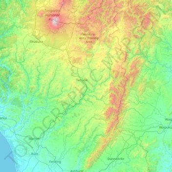
Name: Rangitīkei District topographic map, elevation, terrain.
Location: Rangitīkei District, Manawatū-Whanganui, New Zealand (-40.29635 175.09902 -39.13449 176.34073)
Average elevation: 538 m
Minimum elevation: 0 m
Maximum elevation: 2,727 m
Other topographic maps
Click on a map to view its topography, its elevation and its terrain.
Cone
New Zealand > Manawatū-Whanganui > Tararua District
Cone, Tararua District, Manawatū-Whanganui, New Zealand
Average elevation: 338 m