
Romania topographic map
Interactive map
Click on the map to display elevation.
Romania
Romania's topography is a harmonious blend of mountains, hills, and plains, each contributing to the country's diverse landscape. The country is divided into several distinct geographical regions: the Carpathian Mountains, the Transylvanian Plateau, the Moldavian Plateau, and the Danube River Basin. The Carpathians, which form an arc through the center of Romania, are the backbone of the country, with peaks such as Moldoveanu reaching over 2,500 meters. The mountains are rich in forests and rugged terrains, home to many wildlife species. The Transylvanian Plateau, situated between the Carpathians and the Apuseni Mountains, is characterized by rolling hills and fertile valleys, ideal for agriculture. To the southeast, the Danube River creates a vast and flat delta as it approaches the Black Sea, a UNESCO World Heritage site with a labyrinth of waterways and wetlands. The Moldavian Plateau to the east has gentle hills, interspersed with river valleys, and is primarily agricultural. Overall, Romania’s topography is a rich mosaic of mountains, hills, plains, and river basins, offering both natural beauty and rich biodiversity.
About this map
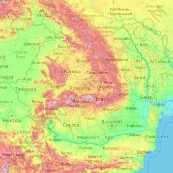
Name: Romania topographic map, elevation, terrain.
Location: Romania (43.61881 20.26200 48.26547 30.04543)
Average elevation: 355 m
Minimum elevation: -3 m
Maximum elevation: 2,426 m
Other topographic maps
Click on a map to view its topography, its elevation and its terrain.
Tbilisi
Most of the raions are named after historic quarters of the city. The citizens of Tbilisi widely recognise an informal system of smaller historic neighbourhoods. Such neighbourhoods are several, however, constituting a kind of hierarchy, because most of them have lost their distinctive topographic limits. The…
Average elevation: 713 m
Dankuni
India > West Bengal > Chanditala - II
Located at an elevation of None meters (0 feet) above sea level, city's yearly temperature is 30.28 °C (86.5 °F) and it is 4.31% higher than India's averages. Dankuni typically receives about 150.21 millimeters (5.91 inches) of precipitation and has 150.54 rainy days (41.24% of the time) annually.
Average elevation: 6 m
Cedar
Canada > British Columbia > Regional District of Nanaimo > Area A (Cassidy/Cedar)
Average elevation: 27 m
Laguna de Santo Tomás
Mexico > Baja California > Municipio de Ensenada > La Bocana
Average elevation: 40 m
Lusaka
Lusaka (/luːˈsɑːkə/ loo-SAH-kə) is the capital and largest city of Zambia. It is one of the fastest-developing cities in southern Africa. Lusaka is in the southern part of the central plateau at an elevation of about 1,279 metres (4,196 ft). As of 2019, the city's population was about 3.3 million, while…
Average elevation: 1,227 m
Europe
Europe's topography is characterized by a striking contrast between its rugged southern mountains and the expansive plains of the north. The continent is often described as a "peninsula of peninsulas," featuring major peninsulas like the Iberian, Italian, and Balkan, each with unique geological features. In…
Average elevation: 223 m
Big Sur
United States > California > Monterey County
The highest peaks of the crest of the coast range are located at an average distance from the coast of three and a half miles [5.6 km]. In this distance they rise to elevations of from three thousand six hundred to five thousand feet [1,100 to 1,500 m] above the sea-level. From San Carpoforo Creek to…
Average elevation: 193 m
Country Club Estates
United States > North Carolina > Alamance County > Burlington
Average elevation: 195 m
Svinjašnica
Bosnia and Herzegovina > Federation of Bosnia and Herzegovina > Town of Zavidovići
Average elevation: 446 m
Tankovoye
Ukraine > Republic of Crimea > Bakhchysarai Raion > Куйбышевское сельское поселение
Average elevation: 169 m
Vredefort
South Africa > Free State > Fezile Dabi District Municipality > Ngwathe Local Municipality
Average elevation: 1,430 m
Monument
United States > Colorado > El Paso County
Monument experiences a hemiboreal continental climate (Köppen Dfb) with warm, relatively rainy summers and cold, snowy winters. The semi-arid climate keeps the dew point very low in Monument year-round which causes the air to feel quite dry. Monument is part of the Front Range urban corridor and lies on the…
Average elevation: 2,160 m
Malvern
United Kingdom > England > Worcestershire > Malvern Hills
Malvern lies in the Lower Severn/Avon plain affording it a degree of shelter caused by virtue of its nestling in between the Cotswold hills to the east, the Welsh Hills and Mountains to the west, and Birmingham plateau to the north. Although as with all the British Isles it has a maritime climate, the local…
Average elevation: 95 m
Tassili n'Ajjer
Tassili n'Ajjer lies within the West Saharan montane xeric woodlands ecoregion. Due to the higher elevation of the area, coupled with the water-retentive properties of the sandstone, the vegetation here is somewhat more lush and verdant than in the lower regions of desert; in turn, this creates an attractive…
Average elevation: 842 m
Toowoomba
The city occupies the edge of the range and the low ridges behind it. Two valleys run north from the southern boundary, each arising from springs either side of Middle Ridge near Spring Street at an altitude of around 680 m. These waterways, East Creek and West Creek, flow together just north of the CBD to…
Average elevation: 458 m
Mount Kosciuszko
Mount Kosciuszko (/ˌkɒziˈʌskoʊ/ KOZ-ee-USK-oh; Polish pronunciation: [kɔɕˈt͡ɕuʂ.kɔ] kosh-CHOOSH-koh; Ngarigo: Kunama Namadgi) is the highest mountain of the mainland Australia, at 2,228 metres (7,310 ft) above sea level. It is located on the Main Range of the Snowy Mountains in Kosciuszko National…
Average elevation: 2,035 m
Harare
Harare (/həˈrɑːreɪ/; formerly Salisbury /ˈsɔːlzbəri/) is the capital and most populous city of Zimbabwe. The city proper has an area of 940 km2 (371 mi2) and a population of 2.12 million in the 2012 census and an estimated 3.12 million in its metropolitan area in 2019. Situated in north-eastern…
Average elevation: 1,470 m
Croydon
Several apartment developments, for instance Altitude 25 (completed 2010), have been built in recent years, and several more are being built or planned. The construction of Saffron Square, which includes a 43-storey tower, began on Wellesley Road in 2011 and was completed in 2016. Other developments with…
Average elevation: 70 m
Reigate
United Kingdom > England > Surrey > Reigate and Banstead
Reigate is in central Surrey, around 19 mi (30 km) south of central London and 9 mi (14 km) north of Gatwick Airport. The town is in the Vale of Holmesdale, below the North Downs escarpment. The average elevation in the centre is 80 m (260 ft) above ordnance datum (OD) and the area is drained by the Wallace…
Average elevation: 100 m
Pacific Ocean
Average elevation: 0 m
Three Kings Deer
United Kingdom > England > Lincolnshire > North Kesteven > Threekingham
Average elevation: 24 m
Farnsworth
United States > Texas > Ochiltree County
Farnsworth is a census designated place in western Ochiltree County, Texas, United States. It lies at the intersection of State Highway 15 with FM376, southwest of the city of Perryton, the county seat of Ochiltree County. Its elevation is 2,995 feet (913 m). Although Farnsworth is unincorporated, it has a…
Average elevation: 913 m