
Make a donation
Gear up for your next adventure:
As an Amazon Associate, this site earns from qualifying purchases at no extra cost to you.
Irish Sea topographic map
Click on the map to display elevation.
Make a donation
Gear up for your next adventure:
As an Amazon Associate, this site earns from qualifying purchases at no extra cost to you.
About this map
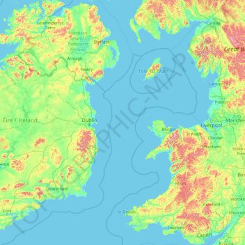
Name: Irish Sea topographic map, elevation, terrain.
Location: Irish Sea (51.37693 -6.64398 55.29212 -3.06381)
Average elevation: 89 m
Minimum elevation: -2 m
Maximum elevation: 989 m
Make a donation
Gear up for your next adventure:
As an Amazon Associate, this site earns from qualifying purchases at no extra cost to you.
Other topographic maps
Click on a map to view its topography, its elevation and its terrain.
Ireland
Ireland's topography is characterized by a central limestone plain, averaging about 75 meters (246 feet) above sea level, interspersed with numerous lakes, bogs, and low ridges. This plain is encircled by coastal mountains of varying geological compositions. In the southwest, the MacGillycuddy's Reeks,…
Average elevation: 44 m
Virginia
Forests cover 62% of Virginia as of 2021, of which 80% is considered hardwood forest, meaning that trees in Virginia are primarily deciduous and broad-leaved. The other 20% is pine, with loblolly and shortleaf pine dominating much of central and eastern Virginia. In the western and mountainous parts of the…
Average elevation: 248 m
Croatia
The territory covers 56,594 square kilometres (21,851 square miles), consisting of 56,414 square kilometres (21,782 square miles) of land and 128 square kilometres (49 square miles) of water. It is the world's 127th largest country. Elevation ranges from the mountains of the Dinaric Alps with the highest point…
Average elevation: 323 m
Make a donation
Gear up for your next adventure:
As an Amazon Associate, this site earns from qualifying purchases at no extra cost to you.
Bangladesh
Bangladesh is predominantly rich fertile flat land. Most of it is less than 12 m (39 ft) above sea level, and it is estimated that about 10% of its land would be flooded if the sea level were to rise by 1 m (3.3 ft). 17% of the country is covered by forests and 12% is covered by hill systems. The country's…
Average elevation: 161 m
Tbilisi
Most of the raions are named after historic quarters of the city. The citizens of Tbilisi widely recognise an informal system of smaller historic neighbourhoods. Such neighbourhoods are several, however, constituting a kind of hierarchy, because most of them have lost their distinctive topographic limits. The…
Average elevation: 713 m
Czechia
Temperatures vary depending on the elevation. In general, at higher altitudes, the temperatures decrease and precipitation increases. The wettest area in the Czech Republic is found around Bílý Potok in Jizera Mountains and the driest region is the Louny District to the northwest of Prague. Another factor is…
Average elevation: 369 m
Make a donation
Gear up for your next adventure:
As an Amazon Associate, this site earns from qualifying purchases at no extra cost to you.
Cork
The climate of Cork, like the majority of Ireland, is mild oceanic (Cfb in the Köppen climate classification) and changeable with abundant rainfall and a lack of temperature extremes. Cork lies in plant Hardiness zone 9b. Met Éireann maintains a climatological weather station at Cork Airport, a few…
Average elevation: 79 m
Patagonia
Across much of Patagonia east of the Andes, volcanic eruptions have created formation of basaltic lava plateaus during the Cenozoic. The plateaus are of different ages with the older –of Neogene and Paleogene age– being located at higher elevations than Pleistocene and Holocene lava plateaus and outcrops.
Average elevation: 173 m
Make a donation
Gear up for your next adventure:
As an Amazon Associate, this site earns from qualifying purchases at no extra cost to you.
Galicia
The interior of Galicia is characterized by a hilly landscape; mountain ranges rise to 2,000 m (6,600 ft) in the east and south. The coastal areas are mostly an alternate series of rias and beaches. The climate of Galicia is usually temperate and rainy, with markedly drier summers; it is usually classified as…
Average elevation: 456 m
Tooele County
Tooele County lies on the west side of Utah. Its west border abuts the east border of the state of Nevada. Its northeast border abuts the Great Salt Lake. Three significant mountain ranges run north-south through the county. Its east boundary line is delineated by the crestline of the Oquirrh Mountains, which…
Average elevation: 1,463 m
Make a donation
Gear up for your next adventure:
As an Amazon Associate, this site earns from qualifying purchases at no extra cost to you.
Bandung
Indonesia > West Java > Bandung
Bandung, the capital of West Java province, located about 180 kilometres (110 mi) southeast of Jakarta, is the third-largest city in Indonesia. Its elevation is 768 metres (2,520 ft) above sea level and is surrounded by up to 2,400 metres (7,900 feet) high Late Tertiary and Quaternary volcanic terrain. The 400…
Average elevation: 879 m
Make a donation
Gear up for your next adventure:
As an Amazon Associate, this site earns from qualifying purchases at no extra cost to you.
County Dublin
Dublin is a topographically varied region. The city centre is generally very low-lying, and many areas of coastal Dublin are at or near sea-level. In the south of the county, the topography rises steeply from sea-level at the coast to over 500 metres (1,600 ft) in just a few kilometres. This natural barrier…
Average elevation: 71 m
Latvia
Coastal regions, especially the western coast of the Courland Peninsula, possess a more maritime climate with cooler summers and milder winters, while eastern parts exhibit a more continental climate with warmer summers and harsher winters. Nevertheless, the temperature variations are little as the territory…
Average elevation: 72 m
Geneva
The altitude of Geneva is 373.6 m (1,225.7 ft) and corresponds to the altitude of the largest of the Pierres du Niton, two large rocks emerging from the lake which date from the last ice age. This rock was chosen by General Guillaume Henri Dufour as the reference point for surveying in Switzerland. The second…
Average elevation: 404 m
Make a donation
Gear up for your next adventure:
As an Amazon Associate, this site earns from qualifying purchases at no extra cost to you.
Europe
Europe's topography is characterized by a striking contrast between its rugged southern mountains and the expansive plains of the north. The continent is often described as a "peninsula of peninsulas," featuring major peninsulas like the Iberian, Italian, and Balkan, each with unique geological features. In…
Average elevation: 223 m
Seattle
United States > Washington > King County
The city is hilly in some places. Like Rome, the city is said to lie on seven hills; the lists vary but typically include Capitol Hill, First Hill, West Seattle, Beacon Hill, Queen Anne, Magnolia, and the former Denny Hill. The Wallingford, Delridge, Mount Baker, Seward Park, Washington Park, Broadmoor,…
Average elevation: 40 m
County Limerick
One possible meaning for the county's name in Irish Luimneach is "the flat area"; this description is accurate as the land consists mostly of a fertile limestone plain. Moreover, the county is ringed by mountains: the Slieve Felims to the northeast, the Galtees to the southeast, the Ballyhoura Mountains to the…
Average elevation: 107 m
Make a donation
Gear up for your next adventure:
As an Amazon Associate, this site earns from qualifying purchases at no extra cost to you.
County Kerry
Bounded by the Atlantic Ocean, Kerry is Ireland's most westerly county. Its rugged coastline stretches for 886 kilometres (551 miles) and is characterised by bays, sea cliffs, beaches and many small offshore islands, of which the Blaskets and the Skelligs are the most notable. The county's peninsulas have a…
Average elevation: 123 m
County Cork
County Cork is located in the province of Munster, bordering Kerry to the west, Limerick to the north, Tipperary to the north-east and Waterford to the east. The county shares separate mountainous borders with Tipperary and Kerry. The terrain on the Kerry border was formed between 360 and 374 million years…
Average elevation: 78 m
Make a donation
Gear up for your next adventure:
As an Amazon Associate, this site earns from qualifying purchases at no extra cost to you.
Make a donation
Gear up for your next adventure:
As an Amazon Associate, this site earns from qualifying purchases at no extra cost to you.
Make a donation
Gear up for your next adventure:
As an Amazon Associate, this site earns from qualifying purchases at no extra cost to you.
County Carlow
The soils of the county are mostly derived from glacial till, rather than solid bedrock geology. These typically consist of a mix of clay, sand and gravel. Occasionally glacial melt-water would form a long ridge of sand and gravel known as an esker. One such example is preserved within the county and is a…
Average elevation: 126 m
Make a donation
Gear up for your next adventure:
As an Amazon Associate, this site earns from qualifying purchases at no extra cost to you.
Brosna
Works, to the cost of IR £750,000, were undertaken on the river in the late 1940s and early 1950s to improve drainage in the river’s catchment area. As part of the Arterial Drainage Scheme, designed to tackle poor drainage caused by Ireland’s relatively low-lying topography, the river was deepened and…
Average elevation: 75 m
Make a donation
Gear up for your next adventure:
As an Amazon Associate, this site earns from qualifying purchases at no extra cost to you.
Make a donation
Gear up for your next adventure:
As an Amazon Associate, this site earns from qualifying purchases at no extra cost to you.
Make a donation
Gear up for your next adventure:
As an Amazon Associate, this site earns from qualifying purchases at no extra cost to you.
Make a donation
Gear up for your next adventure:
As an Amazon Associate, this site earns from qualifying purchases at no extra cost to you.
Make a donation
Gear up for your next adventure:
As an Amazon Associate, this site earns from qualifying purchases at no extra cost to you.
Make a donation
Gear up for your next adventure:
As an Amazon Associate, this site earns from qualifying purchases at no extra cost to you.
Make a donation
Gear up for your next adventure:
As an Amazon Associate, this site earns from qualifying purchases at no extra cost to you.
Make a donation
Gear up for your next adventure:
As an Amazon Associate, this site earns from qualifying purchases at no extra cost to you.
Make a donation
Gear up for your next adventure:
As an Amazon Associate, this site earns from qualifying purchases at no extra cost to you.
Make a donation
Gear up for your next adventure:
As an Amazon Associate, this site earns from qualifying purchases at no extra cost to you.
Make a donation
Gear up for your next adventure:
As an Amazon Associate, this site earns from qualifying purchases at no extra cost to you.
Make a donation
Gear up for your next adventure:
As an Amazon Associate, this site earns from qualifying purchases at no extra cost to you.
Make a donation
Gear up for your next adventure:
As an Amazon Associate, this site earns from qualifying purchases at no extra cost to you.
Make a donation
Gear up for your next adventure:
As an Amazon Associate, this site earns from qualifying purchases at no extra cost to you.