
淮安市 topographic map
Interactive map
Click on the map to display elevation.
About this map
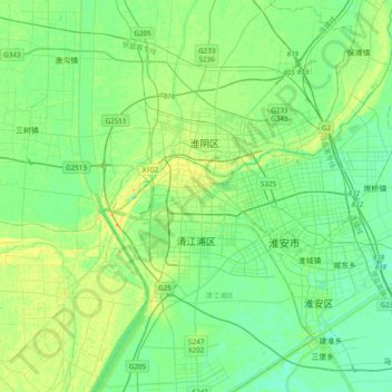
Name: 淮安市 topographic map, elevation, terrain.
Location: 淮安市, 清河区, 淮安市, 江苏省, 223000, 中国 (33.39248 118.94758 33.71248 119.26758)
Average elevation: 11 m
Minimum elevation: 3 m
Maximum elevation: 28 m
淮安市境内绝大部分为辽阔的江淮平原(里下河平原),地势极为平坦。唯有盱眙县有若干丘陵地形分布,铁山寺森林公园的海拔最高点接近200米。
Other topographic maps
Click on a map to view its topography, its elevation and its terrain.